IMAGES TAKEN NEAR TO
Glenfield Road East, GALASHIELS, TD1 2UE
Introduction
This page details the photographs taken nearby to Glenfield Road East, TD1 2UE by members of the Geograph project.
The Geograph project started in 2005 with the aim of publishing, organising and preserving representative images for every square kilometre of Great Britain, Ireland and the Isle of Man.

There are currently over 7.5m images from over14,400 individuals and you can help contribute to the project by visiting https://www.geograph.org.uk
Image Map (Loading...)


Getting Data...Please wait
Leaflet Map data © OpenStreetMap
Images are licensed for reuse under creativecommons.org/licenses/by-sa/2.0
Notes
- Clicking on the map will re-center to the selected point.
- The higher the marker number, the further away the image location is from the centre of the postcode.
Image Listing (116 Images Found)
Images are licensed for reuse under creativecommons.org/licenses/by-sa/2.0
Image
Details
Distance
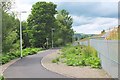
1
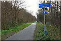
The Black Path, Galashiels
The Black Path is the tarmaced walk and cycle route that follows the old railway line from Gala to Tweedbank near Melrose. Presumably this path will have to be diverted if it is replaced by the proposed new railway to Tweedbank due to open in 2014.
Image: © Jim Barton
Taken: 30 Nov 2011
0.03 miles
2
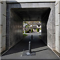
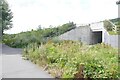
An underpass at Glenfield, Galashiels
This pedestrian access goes under the Borders Railway.
Image: © Walter Baxter
Taken: 16 Apr 2016
0.06 miles
3
The Black Path near Netherdale
The original Black Path from Galashiels centre followed the railway, but now takes a new line parallel to the track before crossing the Gala Water here on to Dale Street.
Image: © Jim Barton
Taken: 17 Feb 2016
0.06 miles
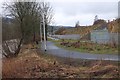
6
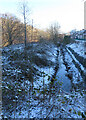
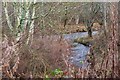
Mill Lade
The lade is one of several that were built to power the mills in Galashiels' heyday as a centre of wool processing, spinning and weaving.
Image: © Anne Burgess
Taken: 15 Dec 2022
0.08 miles
7
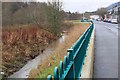
Flood defence wall, Galashiels
Part of a continuous wall, with some gaps for access that can be closed off, on Dale Street alongside the Gala Water.
Image: © Jim Barton
Taken: 17 Feb 2016
0.08 miles
8
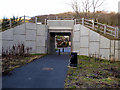
Footpath to Galashiels
The Black Path into Galashiels centre alongside the Borders Railway.
Image: © Jim Barton
Taken: 30 Jun 2015
0.09 miles
9
Mill lade joins the Gala Water
The end of the mill lade that runs about 2.5km through the town from the cauld (weir) shown in Image, powering a succession of textile mills alongside the Gala Water.
Image: © Jim Barton
Taken: 17 Jan 2020
0.09 miles
10
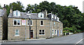
Larchbank Street
At the junction with Dale Street, which becomes Huddersfield Street beyond this point.
Image: © Thomas Nugent
Taken: 26 Sep 2015
0.09 miles