IMAGES TAKEN NEAR TO
Stow, GALASHIELS, TD1 2QL
Introduction
This page details the photographs taken nearby to TD1 2QL by members of the Geograph project.
The Geograph project started in 2005 with the aim of publishing, organising and preserving representative images for every square kilometre of Great Britain, Ireland and the Isle of Man.

There are currently over 7.5m images from over14,400 individuals and you can help contribute to the project by visiting https://www.geograph.org.uk
Image Map (Loading...)


Getting Data...Please wait
Leaflet Map data © OpenStreetMap
Images are licensed for reuse under creativecommons.org/licenses/by-sa/2.0
Notes
- Clicking on the map will re-center to the selected point.
- The higher the marker number, the further away the image location is from the centre of the postcode.
Image Listing (9 Images Found)
Images are licensed for reuse under creativecommons.org/licenses/by-sa/2.0
Image
Details
Distance
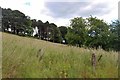
2
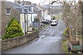
Autumn lane at Townhead, Stow
A no through road to the cemetery and Muirhouse.
Image: © M J Richardson
Taken: 8 Oct 2014
0.07 miles
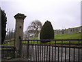
3

Stow Cemetery
A small storage building is at the northeast corner of the cemetery.
Image: © Walter Baxter
Taken: 14 Jan 2022
0.09 miles
4
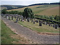
Stow Cemetery
Hillside cemetery east of Stow.
Image: © Adam Ward
Taken: 25 Jul 2006
0.10 miles
5
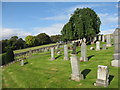
Cemetery at Stow
With a fine weeping ash.
Image: © M J Richardson
Taken: 8 Oct 2014
0.12 miles
7
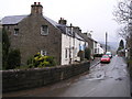
Townhead, Stow
The eastern edge of the village on the descent towards the A7 with the bridge over the Crunzie Burn in the foreground.
Image: © Jim Barton
Taken: 11 Mar 2020
0.24 miles
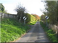
8
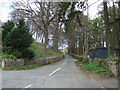
Road towards Muirhouse
Heads east from Stow.
Image: © JThomas
Taken: 20 Apr 2017
0.25 miles