IMAGES TAKEN NEAR TO
Blainslie, GALASHIELS, TD1 2PP
Introduction
This page details the photographs taken nearby to TD1 2PP by members of the Geograph project.
The Geograph project started in 2005 with the aim of publishing, organising and preserving representative images for every square kilometre of Great Britain, Ireland and the Isle of Man.

There are currently over 7.5m images from over14,400 individuals and you can help contribute to the project by visiting https://www.geograph.org.uk
Image Map
Images are licensed for reuse under creativecommons.org/licenses/by-sa/2.0
Notes
- Clicking on the map will re-center to the selected point.
- The higher the marker number, the further away the image location is from the centre of the postcode.
Image Listing (7 Images Found)
Images are licensed for reuse under creativecommons.org/licenses/by-sa/2.0
Image
Details
Distance
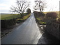
1
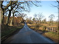
Country road near Nether Blainslie
The trees are bare on this fine Winter's day.
Image: © James Denham
Taken: 13 Jan 2009
0.04 miles
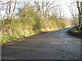
3
Minor road at Blainslie
In the Scottish Borders.
Image: © James Denham
Taken: 13 Jan 2009
0.08 miles
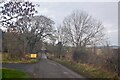
4
Road Junction at Blainslie
Junction leading to the A68
Image: © James Denham
Taken: 13 Jan 2009
0.11 miles
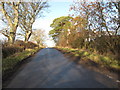
5
Minor road heading towards Earlston
Leading away from Blainslie.
Image: © James Denham
Taken: 13 Jan 2009
0.13 miles
6
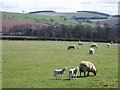
Near Nether Blainslie
Sheep with their lambs near the hamlet of Nether Blainslie, to the south-east of Lauder.
Image: © Eileen Henderson
Taken: 14 Apr 2006
0.20 miles
7
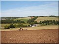
Cuddyhall
Ploughing in Lauderdale, the house is Cuddyhall.
Image: © Richard Webb
Taken: 15 Sep 2006
0.22 miles