IMAGES TAKEN NEAR TO
GALASHIELS, TD1 2PJ
Introduction
This page details the photographs taken nearby to TD1 2PJ by members of the Geograph project.
The Geograph project started in 2005 with the aim of publishing, organising and preserving representative images for every square kilometre of Great Britain, Ireland and the Isle of Man.

There are currently over 7.5m images from over14,400 individuals and you can help contribute to the project by visiting https://www.geograph.org.uk
Image Map (Loading...)


Getting Data...Please wait
Leaflet Map data © OpenStreetMap
Images are licensed for reuse under creativecommons.org/licenses/by-sa/2.0
Notes
- Clicking on the map will re-center to the selected point.
- The higher the marker number, the further away the image location is from the centre of the postcode.
Image Listing (8 Images Found)
Images are licensed for reuse under creativecommons.org/licenses/by-sa/2.0
Image
Details
Distance
4
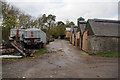
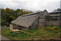
Kedslie
Farm with straw stored outside.
Image: © Richard Webb
Taken: 15 Sep 2006
0.06 miles
6

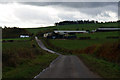
Mud on road
A consequence of a long period of heavy rainfall before the ploughing season. The first dry spell in months has triggered a lot of field working.
Image: © Richard Webb
Taken: 20 Feb 2013
0.11 miles
7
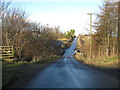
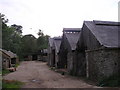
Bridge over the burn at Kedslie
The road passes what appears to be a disused farm near Blainslie.
Image: © James Denham
Taken: 12 Jan 2009
0.13 miles
8
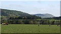
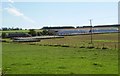
Kedslie
Cattle torn between grazing and checking out what was happening over the hedge, where other cattle were being herded. There is a view of Black Hill of Earlston.
Image: © Richard Webb
Taken: 21 May 2012
0.17 miles