IMAGES TAKEN NEAR TO
GALASHIELS, TD1 2PH
Introduction
This page details the photographs taken nearby to TD1 2PH by members of the Geograph project.
The Geograph project started in 2005 with the aim of publishing, organising and preserving representative images for every square kilometre of Great Britain, Ireland and the Isle of Man.

There are currently over 7.5m images from over14,400 individuals and you can help contribute to the project by visiting https://www.geograph.org.uk
Image Map (Loading...)


Getting Data...Please wait
Leaflet Map data © OpenStreetMap
Images are licensed for reuse under creativecommons.org/licenses/by-sa/2.0
Notes
- Clicking on the map will re-center to the selected point.
- The higher the marker number, the further away the image location is from the centre of the postcode.
Image Listing (27 Images Found)
Images are licensed for reuse under creativecommons.org/licenses/by-sa/2.0
Image
Details
Distance
1
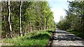
Strip wood and minor road, Lauderdale
A long straight minor road running beside a strip wood.
Image: © Richard Webb
Taken: 21 May 2012
0.05 miles
2
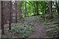
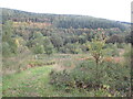
Woodland path, Carolside
The waymarked route of the Earlston Circular path heading through woodland towards Clackmae Dean.
Image: © Jim Barton
Taken: 31 Jul 2015
0.06 miles
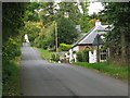
3
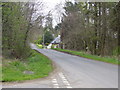
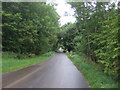
A cottage in the country
Looking along the way to Blainslie from the junction with the Langshaw road
Image: © James Denham
Taken: 3 May 2008
0.06 miles
4
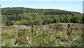
Carolside woodlands
A felled area in the foreground with the mature Blinkbonny Woodlands on the other side of the Leader Water (and A68).
Image: © Richard Webb
Taken: 21 May 2012
0.07 miles
5
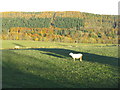
Looking across Lauderdale
Farmland and forestry plantations providing autumn colour, with Carolsidehill Wood on Huntshaw Hill.
Image: © M J Richardson
Taken: 2 Nov 2012
0.07 miles
6
Woodland, Leadervale
A waymarked path runs down to river level via woodland. This area of young scattered trees was very rich in raspberry canes.
Image: © Richard Webb
Taken: 8 Oct 2022
0.08 miles
7
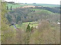
Leader Water at Carolside
View over the estate of Carolside from a path through the woodland on the eastern side of the A68 road, which can just be seen at the bottom of the photo. The path is part of a recently created walking route, the Earlston Circular, which descends from this woodland to the river (Leader Water) before returning to Earlston. The bridge on the left of the photo is Park Bridge Image
Image: © Eileen Henderson
Taken: 3 May 2008
0.08 miles
9
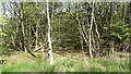
A strip wood
A roadside strip wood in Lauderdale. The policies of Carolside lie the other side.
Image: © Richard Webb
Taken: 21 May 2012
0.09 miles
10
Lodge, Clackmae Dean
Looking uphill and into the next square. The edge of the square lies just beyond the lodge house.
Image: © Callum Black
Taken: 7 Oct 2007
0.09 miles