IMAGES TAKEN NEAR TO
Hawthorn Road, GALASHIELS, TD1 2JY
Introduction
This page details the photographs taken nearby to Hawthorn Road, TD1 2JY by members of the Geograph project.
The Geograph project started in 2005 with the aim of publishing, organising and preserving representative images for every square kilometre of Great Britain, Ireland and the Isle of Man.

There are currently over 7.5m images from over14,400 individuals and you can help contribute to the project by visiting https://www.geograph.org.uk
Image Map (Loading...)


Getting Data...Please wait
Leaflet Map data © OpenStreetMap
Images are licensed for reuse under creativecommons.org/licenses/by-sa/2.0
Notes
- Clicking on the map will re-center to the selected point.
- The higher the marker number, the further away the image location is from the centre of the postcode.
Image Listing (108 Images Found)
Images are licensed for reuse under creativecommons.org/licenses/by-sa/2.0
Image
Details
Distance
1
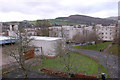
Flats at Langlee
The kind of development that looks better on the architect's drawing than in real life; Gala Hill is in the background.
Image: © Jim Barton
Taken: 30 Nov 2011
0.03 miles
2
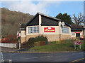
The Woodcutter, Langlee
A pub in the Langlee district of Galashiels.
Image: © Jim Barton
Taken: 31 Jan 2023
0.03 miles
3
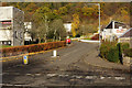
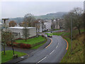
Hawthorn Road, Langlee
Leading off Melrose Road in the Galashiels suburbs. The Woodcutter pub still sports a 'yes' poster over two years after the Scottish independence referendum.
Image: © Stephen McKay
Taken: 16 Nov 2016
0.03 miles
4
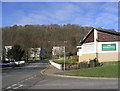
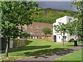
Langlee Housing Estate
Housing scheme on the north side of Melrose Road, built in the late 1960s. This is a view up Hawthorn Road with the Woodcutter pub on the right and Langlee Woodlands in the background. This woodland was recently awarded a grant from a Forestry Commission funding proramme called 'Woods in and Around Town' (WIAT) initiative. The aim is to improve access to the woodland, build new footpaths and plant new trees.
Image: © Walter Baxter
Taken: 5 Feb 2007
0.04 miles
5
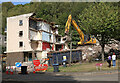
Demolition work at Langlee, Galashiels
The demolition of 159 properties and 64 garages in Beech Avenue and Larch Grove began in August 2022 as part of the Upper Langlee Regeneration Project. 109 new homes will be constructed on the site by Waverley Homes. The original houses were erected in the late 1960s and early 1970s.
Image: © Walter Baxter
Taken: 5 Sep 2022
0.04 miles
6
Langlee Housing Estate
Social housing of the late 1960s and early 1970s on the north side of Melrose Road in Galashiels.
Image: © Walter Baxter
Taken: 10 May 2007
0.04 miles
7
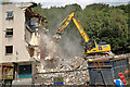
Demolition work at Langlee, Galashiels
The demolition of 159 properties and 64 garages in Beech Avenue and Larch Grove began in August 2022 as part of the Upper Langlee Regeneration Project. 109 new homes will be constructed on the site by Waverley Homes. The original houses were erected in the late 1960s and early 1970s.
Image: © Walter Baxter
Taken: 5 Sep 2022
0.04 miles
8
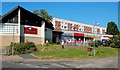
Langlee Shops
A local shopping area in the Langlee housing scheme at Galashiels.
Image: © Mary and Angus Hogg
Taken: 31 May 2009
0.05 miles
9
Hawthorn Road, Langlee
Image: © Jim Barton
Taken: 1 Dec 2022
0.05 miles
10
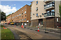
Demolition work at Langlee, Galashiels
The demolition of 159 properties and 64 garages in Beech Avenue and Larch Grove began in August 2022 as part of the Upper Langlee Regeneration Project. 109 new homes will be constructed on the site by Waverley Homes. The original houses were erected in the late 1960s and early 1970s.
Image: © Walter Baxter
Taken: 5 Sep 2022
0.05 miles