IMAGES TAKEN NEAR TO
Glendinning Terrace, GALASHIELS, TD1 2JR
Introduction
This page details the photographs taken nearby to Glendinning Terrace, TD1 2JR by members of the Geograph project.
The Geograph project started in 2005 with the aim of publishing, organising and preserving representative images for every square kilometre of Great Britain, Ireland and the Isle of Man.

There are currently over 7.5m images from over14,400 individuals and you can help contribute to the project by visiting https://www.geograph.org.uk
Image Map (Loading...)


Getting Data...Please wait
Leaflet Map data © OpenStreetMap
Images are licensed for reuse under creativecommons.org/licenses/by-sa/2.0
Notes
- Clicking on the map will re-center to the selected point.
- The higher the marker number, the further away the image location is from the centre of the postcode.
Image Listing (128 Images Found)
Images are licensed for reuse under creativecommons.org/licenses/by-sa/2.0
Image
Details
Distance
1
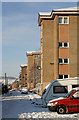
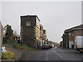
Halliburton Place, Galashiels
This street is on the northeast side of the town. The high rise flats replaced more traditional housing at this end.
Image: © Walter Baxter
Taken: 20 Dec 2010
0.03 miles
2
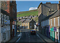
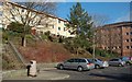
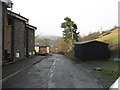
Glendinning Terrace, Galashiels
Post-War council housing development on the lower slopes of Buckholm Hill. Being built in the narrow valley of the Gala Water, the streets here follow the contour lines in true terrace style.
Image: © Mary and Angus Hogg
Taken: 14 Mar 2009
0.03 miles
3
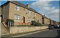
Glendinning Terrace
Looking uphill, to a terrace of houses with some rather ungainly loft extensions.
Image: © M J Richardson
Taken: 28 Jan 2015
0.04 miles
4
Flats In Halliburton Place
This residential development replaced an older tenement-type housing area in Galashiels. The tall block on the right is only just inside the square. There are two other blocks further along the street.
Image: © Mary and Angus Hogg
Taken: 14 Mar 2009
0.05 miles
5
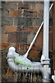
Frozen solid
This cleaning mop wedged behind the downpipe has frozen up with icicles along with the pipe branch. Photographed on a house in Magdala Terrace, Galashiels.
Image: © Walter Baxter
Taken: 7 Jan 2010
0.07 miles
6
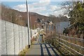
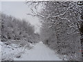
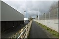
Cyclepath approaching Galashiels
The path alongside the Borders Railway NW of the town centre.
Image: © Jim Barton
Taken: 20 Mar 2018
0.09 miles
7
Glendinning Terrace, Galashiels
Looking downhill, back to the town.
Image: © M J Richardson
Taken: 28 Jan 2015
0.10 miles
8
Path, Galashiels
Sandwiched between a PC World tin shed and the Borders Railway.
Image: © Richard Webb
Taken: 12 Mar 2017
0.10 miles