IMAGES TAKEN NEAR TO
Langshaw Road, GALASHIELS, TD1 2FE
Introduction
This page details the photographs taken nearby to Langshaw Road, TD1 2FE by members of the Geograph project.
The Geograph project started in 2005 with the aim of publishing, organising and preserving representative images for every square kilometre of Great Britain, Ireland and the Isle of Man.

There are currently over 7.5m images from over14,400 individuals and you can help contribute to the project by visiting https://www.geograph.org.uk
Image Map (Loading...)


Getting Data...Please wait
Leaflet Map data © OpenStreetMap
Images are licensed for reuse under creativecommons.org/licenses/by-sa/2.0
Notes
- Clicking on the map will re-center to the selected point.
- The higher the marker number, the further away the image location is from the centre of the postcode.
Image Listing (5 Images Found)
Images are licensed for reuse under creativecommons.org/licenses/by-sa/2.0
Image
Details
Distance
1

Pastures in the valley of the Allan Water
And a muddy field entrance. Looking across to Langlee Mains Farmhouse.
Image: © M J Richardson
Taken: 7 Feb 2023
0.12 miles
2
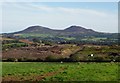
Langlee landfill
Landfill site with a view. Above Galashiels and Melrose with a fine view of the Eildon Hills.
Image: © Richard Webb
Taken: 15 Sep 2006
0.12 miles
3
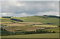
Newly cut fields, Langlee
Plastic-wrapped bales dot the fields near Langlee Mains farm, seen from the Southern Upland Way on Gateside Bank.
Image: © Jim Barton
Taken: 1 Jul 2011
0.16 miles
4
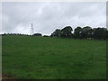
Grazing and pylon near Black Andrew Plantation
Image: © JThomas
Taken: 7 Sep 2017
0.18 miles
5
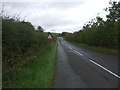
Minor road towards Lauder
Looking north west.
Image: © JThomas
Taken: 7 Sep 2017
0.22 miles