IMAGES TAKEN NEAR TO
Bill Lamb Crescent, GALASHIELS, TD1 2FB
Introduction
This page details the photographs taken nearby to Bill Lamb Crescent, TD1 2FB by members of the Geograph project.
The Geograph project started in 2005 with the aim of publishing, organising and preserving representative images for every square kilometre of Great Britain, Ireland and the Isle of Man.

There are currently over 7.5m images from over14,400 individuals and you can help contribute to the project by visiting https://www.geograph.org.uk
Image Map (Loading...)


Getting Data...Please wait
Leaflet Map data © OpenStreetMap
Images are licensed for reuse under creativecommons.org/licenses/by-sa/2.0
Notes
- Clicking on the map will re-center to the selected point.
- The higher the marker number, the further away the image location is from the centre of the postcode.
Image Listing (19 Images Found)
Images are licensed for reuse under creativecommons.org/licenses/by-sa/2.0
Image
Details
Distance
1
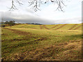
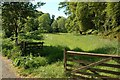
Proposed housing site at Easter Langlee
This is part of a 65 acre site on the eastern outskirts of Galashiels that will see 493 new houses built if planning permission is granted to Persimmon Homes who wish to develop the site in 2 phases. The land has been zoned for housing in the Scottish Borders Council Finalised Local Plan (although for a maximum of 300 housing units) and the development would increase the population of Galashiels by almost 2000 and overtake Hawick as the largest town in the Scottish Borders. The most up to date figures from the General Register Office for Scotland has Hawick with 14,300 residents and Galashiels with 13,900.
Image: © Walter Baxter
Taken: 27 Jan 2008
0.02 miles
2
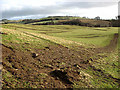
Farmland zoned for housing at Easter Langlee
This is part of a 65 acre site on the eastern outskirts of Galashiels that will see 493 new houses built if planning permission is granted to Persimmon Homes who wish to develop the site in 2 phases. The land has been zoned for housing in the Scottish Borders Council Finalised Local Plan (although for a maximum of 300 housing units) and the development would increase the population of Galashiels by almost 2000 and overtake Hawick as the largest town in the Scottish Borders. The most up to date figures from the General Register Office for Scotland has Hawick with 14,300 residents and Galashiels with 13,900.
Image: © Walter Baxter
Taken: 27 Jan 2008
0.04 miles
3
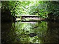
The remains of a bridge over the Allan or Ellwyn Water, Ellwyn Glen
Image: © Iain Lees
Taken: 20 Jun 2009
0.11 miles
7
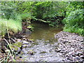
Old Bridge in the Ellwyn Glen
The Edwardians put up bridges which crossed back and forward over the Allan Water in the Fairie Glen. The Town's folk of Galashiels call the river The Ellwyn, hence "Ellwyn's Fairie Glen". I hope the council put the paths and bridges back some day, as it would have been something to see in its prime.
Image: © Iain Lees
Taken: 20 Jun 2009
0.18 miles
9
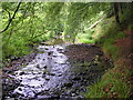
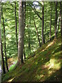
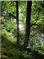
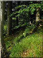
Looking Into Ellwyn Glen
The start of Ellwyn Glen, which used to be a popular walk and picnic spot. It's not easy to get far up the glen nowadays.
Image: © Mary and Angus Hogg
Taken: 31 May 2009
0.20 miles
10
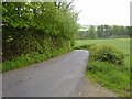
Country road near Gattonside
This road leads to Pavilion arm and the Melrose Road beyond. East of Langlee in Galashiels
Image: © James Denham
Taken: 20 May 2008
0.21 miles