IMAGES TAKEN NEAR TO
Currie Road, GALASHIELS, TD1 2BP
Introduction
This page details the photographs taken nearby to Currie Road, TD1 2BP by members of the Geograph project.
The Geograph project started in 2005 with the aim of publishing, organising and preserving representative images for every square kilometre of Great Britain, Ireland and the Isle of Man.

There are currently over 7.5m images from over14,400 individuals and you can help contribute to the project by visiting https://www.geograph.org.uk
Image Map
Images are licensed for reuse under creativecommons.org/licenses/by-sa/2.0
Notes
- Clicking on the map will re-center to the selected point.
- The higher the marker number, the further away the image location is from the centre of the postcode.
Image Listing (259 Images Found)
Images are licensed for reuse under creativecommons.org/licenses/by-sa/2.0
Image
Details
Distance
1
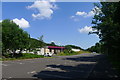
Currie Road car park, Galashiels
Another FREE car park (it's Scotland). Almost entirely empty.
Image: © Tim Heaton
Taken: 18 Jul 2017
0.03 miles
2
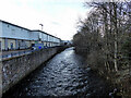
Gala Water
Running through Galashiels. Viewed from a footbridge over the river.
Image: © John Lucas
Taken: 26 Jan 2018
0.04 miles
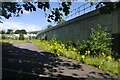
3
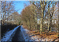
Riverside Path
The path here is on the left bank of the Gala Water, in order to avoid a mill complex on the right bank.
Image: © Anne Burgess
Taken: 15 Dec 2022
0.04 miles
4
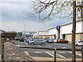
Gala Water Retail Park
A large Tesco supermarket and several other well-known retailers.
Image: © Jim Barton
Taken: 17 Apr 2022
0.05 miles
5
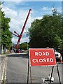
Road closed
Glenfield Road West in Galashiels was temporarily closed to allow a large crane to move large steelwork sections during the construction of a bridge to carry the new Borders Railway. The Borders Railway, scheduled to open in the summer of 2015, will run from Tweedbank in the Scottish Borders to Edinburgh on the rote of the former Waverley Line which was closed in 1969.
Image: © Walter Baxter
Taken: 26 May 2014
0.06 miles
6
Footbridge across Gala Water
Provides a link between the Southern Uplands long distance path and Galashiels town centre.
Image: © John Lucas
Taken: 26 Jan 2018
0.06 miles
7
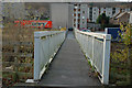
Footbridge over the Gala Water
A footbridge connecting the Black Path alongside Currie Road with housing on Huddersfield Street.
Image: © Jim Barton
Taken: 30 Nov 2011
0.06 miles
8
Lost carpark, Galashiels
The wall carries the Borders Railway.
Image: © Richard Webb
Taken: 28 Jul 2020
0.06 miles
9
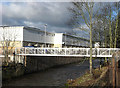
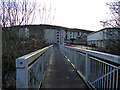
Footbridge over the Gala Water
This new bridge provides a link from the long stay car park in Currie Road to the Gala Water Retail Units in Huddersfield Street, that were opened in the autumn of 2007.
Image: © Walter Baxter
Taken: 1 Mar 2008
0.06 miles
10
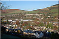
Galashiels from the south
Part of the town seen from the Southern Upland Way on Gala Hill, with suburban housing around the busy centre. Buckholm Hill (L) is in the background.
Image: © Jim Barton
Taken: 6 Nov 2011
0.06 miles