IMAGES TAKEN NEAR TO
MINDRUM, TD12 4QL
Introduction
This page details the photographs taken nearby to TD12 4QL by members of the Geograph project.
The Geograph project started in 2005 with the aim of publishing, organising and preserving representative images for every square kilometre of Great Britain, Ireland and the Isle of Man.

There are currently over 7.5m images from over14,400 individuals and you can help contribute to the project by visiting https://www.geograph.org.uk
Image Map (Loading...)


Getting Data...Please wait
Leaflet Map data © OpenStreetMap
Images are licensed for reuse under creativecommons.org/licenses/by-sa/2.0
Notes
- Clicking on the map will re-center to the selected point.
- The higher the marker number, the further away the image location is from the centre of the postcode.
Image Listing (7 Images Found)
Images are licensed for reuse under creativecommons.org/licenses/by-sa/2.0
Image
Details
Distance
1
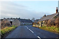
Cottages and buildings, Mindrumill
On the B6352 towards Kelso.
Image: © Robin Webster
Taken: 23 Dec 2019
0.03 miles
2
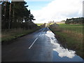
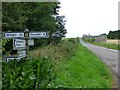
Looking along the B6496
From the crossroads at Mindrum Mill.
Image: © James Denham
Taken: 8 Mar 2009
0.09 miles
3
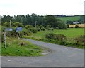
The turn-off to Pawston
From the B6352.
Image: © Russel Wills
Taken: 9 Sep 2016
0.10 miles
4
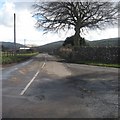
Heading for Mindrum Station
In the Northumberland countryside.
Image: © James Denham
Taken: 8 Mar 2009
0.13 miles
5
Road junction at Mindrum Mill
Looking up the hill to Mindrummill Cottages.
Image: © Russel Wills
Taken: 9 Sep 2016
0.14 miles
6

Bowmont Water
Image: © Hill Walker
Taken: 1 May 2006
0.20 miles
