IMAGES TAKEN NEAR TO
COLDSTREAM, TD12 4JB
Introduction
This page details the photographs taken nearby to TD12 4JB by members of the Geograph project.
The Geograph project started in 2005 with the aim of publishing, organising and preserving representative images for every square kilometre of Great Britain, Ireland and the Isle of Man.

There are currently over 7.5m images from over14,400 individuals and you can help contribute to the project by visiting https://www.geograph.org.uk
Image Map (Loading...)


Getting Data...Please wait
Leaflet Map data © OpenStreetMap
Images are licensed for reuse under creativecommons.org/licenses/by-sa/2.0
Notes
- Clicking on the map will re-center to the selected point.
- The higher the marker number, the further away the image location is from the centre of the postcode.
Image Listing (4 Images Found)
Images are licensed for reuse under creativecommons.org/licenses/by-sa/2.0
Image
Details
Distance
1
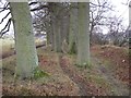
Oak Strip, Leitholm
A view looking west along the Oak Strip near to Leitholm and Lambden Burn.
Image: © Sue Rahman
Taken: Unknown
0.17 miles
2
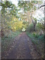
Path leading to footbridge over Lambden Burn
Part of the walk you can take from Leitholm starting from the Kirk, down to the footbridge over Lambden burn, along the oak strip and back around to Leitholm. The photo is taken looking towards Leitholm and the footbridge. Lambden Burn flows into Leet water which is a tributary of the River Tweed.
Image: © Sue Rahman
Taken: 28 Oct 2008
0.19 miles
3
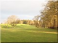
Belchester
This area is dominated by a series of small hills all running along a SW-NE axis. This one was home to a hillfort, now part of the grounds of Belchester House.
Image: © Richard Webb
Taken: 22 Dec 2006
0.19 miles
4
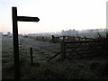
Signpost for Belchester and the Oak Strip
Taken on a frosty October morning.
Image: © Sue Rahman
Taken: Unknown
0.24 miles