IMAGES TAKEN NEAR TO
COLDSTREAM, TD12 4JA
Introduction
This page details the photographs taken nearby to TD12 4JA by members of the Geograph project.
The Geograph project started in 2005 with the aim of publishing, organising and preserving representative images for every square kilometre of Great Britain, Ireland and the Isle of Man.

There are currently over 7.5m images from over14,400 individuals and you can help contribute to the project by visiting https://www.geograph.org.uk
Image Map
Images are licensed for reuse under creativecommons.org/licenses/by-sa/2.0
Notes
- Clicking on the map will re-center to the selected point.
- The higher the marker number, the further away the image location is from the centre of the postcode.
Image Listing (4 Images Found)
Images are licensed for reuse under creativecommons.org/licenses/by-sa/2.0
Image
Details
Distance
1
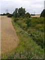
Field Boundary Near Todrig
A small burn (a tributary of the Leet Water) runs through this gully near Todrig Farm. In the background, partially obscured by trees is Eccles substation.
Image: © James T M Towill
Taken: 11 Aug 2012
0.18 miles
2
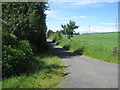
Access road to Todrig Farm
Near Darnchester West Mains.
Image: © James Denham
Taken: 21 Jun 2010
0.20 miles
3
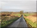
Road near Belchester, Berwickshire.
Like many Merse roads, this one is straight, running up and down the flanks of the many drumlin like hills. A powerline crosses here, close to the Eccles substation.
Image: © Richard Webb
Taken: 22 Dec 2006
0.24 miles
4
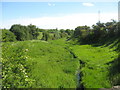
Tiny burn making its way to the Leet Water
Near Darnchester West Mains.
Image: © James Denham
Taken: 21 Jun 2010
0.24 miles