IMAGES TAKEN NEAR TO
COLDSTREAM, TD12 4HY
Introduction
This page details the photographs taken nearby to TD12 4HY by members of the Geograph project.
The Geograph project started in 2005 with the aim of publishing, organising and preserving representative images for every square kilometre of Great Britain, Ireland and the Isle of Man.

There are currently over 7.5m images from over14,400 individuals and you can help contribute to the project by visiting https://www.geograph.org.uk
Image Map (Loading...)


Getting Data...Please wait
Leaflet Map data © OpenStreetMap
Images are licensed for reuse under creativecommons.org/licenses/by-sa/2.0
Notes
- Clicking on the map will re-center to the selected point.
- The higher the marker number, the further away the image location is from the centre of the postcode.
Image Listing (7 Images Found)
Images are licensed for reuse under creativecommons.org/licenses/by-sa/2.0
Image
Details
Distance
1
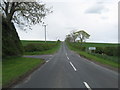
Minor road near Georgefield
Heading in a northerly direction past the Darnchester junction.
Image: © James Denham
Taken: 11 May 2010
0.03 miles
2
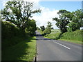
Minor road towards Duns Georgefield
Heading north west.
Image: © JThomas
Taken: 25 Jun 2016
0.04 miles

4
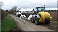
Fertiliser, Georgefield
Large bags of nitrates prior to distribution on newly cultivated fields.
Image: © Richard Webb
Taken: 26 Mar 2011
0.07 miles
5
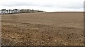
Drumlin, Georgefield
Newly cultivated field on one of the many parallel small hills north of Coldstream.
Image: © Richard Webb
Taken: 26 Mar 2011
0.16 miles
6
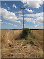
Georgefield
Typical of Berwickshire farmland in this area.
Image: © Lisa Jarvis
Taken: 30 Jul 2006
0.17 miles
7
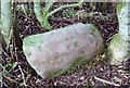
Old Milestone near Georgefield, Coldstream Parish
By the UC road, in parish of Coldstream (Berwick District), Georgefield, hedge bottom.
Inscription once read:- : (Duns / 7¾) : : (Coldstream / 2½) :
Surveyed
Milestone Society National ID: BD_DNCS07
Image: © Milestone Society
Taken: Unknown
0.19 miles