IMAGES TAKEN NEAR TO
COLDSTREAM, TD12 4EY
Introduction
This page details the photographs taken nearby to TD12 4EY by members of the Geograph project.
The Geograph project started in 2005 with the aim of publishing, organising and preserving representative images for every square kilometre of Great Britain, Ireland and the Isle of Man.

There are currently over 7.5m images from over14,400 individuals and you can help contribute to the project by visiting https://www.geograph.org.uk
Image Map
Images are licensed for reuse under creativecommons.org/licenses/by-sa/2.0
Notes
- Clicking on the map will re-center to the selected point.
- The higher the marker number, the further away the image location is from the centre of the postcode.
Image Listing (3 Images Found)
Images are licensed for reuse under creativecommons.org/licenses/by-sa/2.0
Image
Details
Distance
1
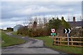
Entrance to Oxenrig
The access road for cottages and the farm.
Image: © Jim Barton
Taken: 3 Mar 2016
0.04 miles
2
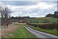
The road from Lennel
The back road from Lennel to Oxenrigs and Coldstream Mains.
Image: © Jim Barton
Taken: 3 Mar 2016
0.20 miles
3
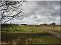
Looking towards Oxenrig
North of the village of Lennel in Berwickshire
Image: © James Denham
Taken: 15 Feb 2012
0.22 miles