IMAGES TAKEN NEAR TO
Priory Hill, COLDSTREAM, TD12 4EB
Introduction
This page details the photographs taken nearby to Priory Hill, TD12 4EB by members of the Geograph project.
The Geograph project started in 2005 with the aim of publishing, organising and preserving representative images for every square kilometre of Great Britain, Ireland and the Isle of Man.

There are currently over 7.5m images from over14,400 individuals and you can help contribute to the project by visiting https://www.geograph.org.uk
Image Map
Images are licensed for reuse under creativecommons.org/licenses/by-sa/2.0
Notes
- Clicking on the map will re-center to the selected point.
- The higher the marker number, the further away the image location is from the centre of the postcode.
Image Listing (17 Images Found)
Images are licensed for reuse under creativecommons.org/licenses/by-sa/2.0
Image
Details
Distance

4

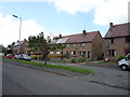
Playground, Guards Road
This between a small industrial estate and a residential area.
Image: © Richard Webb
Taken: 2 Jul 2010
0.08 miles
6
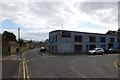
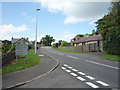
Duns Road
Looking along Duns Road in Coldstream at a fibre optics company.
Image: © DS Pugh
Taken: 1 Sep 2014
0.17 miles
7
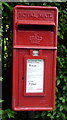
Close up, Elizabeth II postbox on Bennecourt Drive, Coldstream
Postbox No. TD12 165.
See Image] for wider view.
Image: © JThomas
Taken: 25 Jun 2016
0.17 miles
8
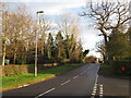
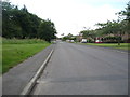
Duns Road, Coldstream
Looking towards the town centre.
Image: © Richard Webb
Taken: 11 Jan 2022
0.17 miles
9
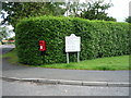
Elizabeth II postbox on Bennecourt Drive, Coldstream
Postbox No. TD12 165.
See Image] for close up.
Image: © JThomas
Taken: 25 Jun 2016
0.17 miles