IMAGES TAKEN NEAR TO
Windsor Locks, DUNS, TD11 3XD
Introduction
This page details the photographs taken nearby to Windsor Locks, TD11 3XD by members of the Geograph project.
The Geograph project started in 2005 with the aim of publishing, organising and preserving representative images for every square kilometre of Great Britain, Ireland and the Isle of Man.

There are currently over 7.5m images from over14,400 individuals and you can help contribute to the project by visiting https://www.geograph.org.uk
Image Map (Loading...)


Getting Data...Please wait
Leaflet Map data © OpenStreetMap
Images are licensed for reuse under creativecommons.org/licenses/by-sa/2.0
Notes
- Clicking on the map will re-center to the selected point.
- The higher the marker number, the further away the image location is from the centre of the postcode.
Image Listing (58 Images Found)
Images are licensed for reuse under creativecommons.org/licenses/by-sa/2.0
Image
Details
Distance
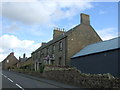
1
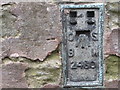
Ordnance Survey Flush Bracket 2430
This can be found on the wall of the currently closed and disused Robins Nest PH in Chirnside.
For more detail see : http://www.bench-marks.org.uk/bm646
Image: © Peter Wood
Taken: 4 Oct 2016
0.04 miles
2
Main Street West End
Central Chirnside.
Image: © James Allan
Taken: 30 May 2015
0.05 miles
3
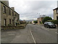
Main Street West End (B6335) in Chirnside
Looking westward from the currently closed and disused Robins Nest PH.
Image: © Peter Wood
Taken: 4 Oct 2016
0.05 miles
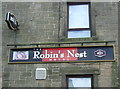
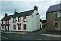
5
Robins Nest Hotel, Chirnside
On Main Street West End.
Image: © JThomas
Taken: 27 Jul 2017
0.06 miles
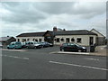
6

Post Office and shop, Chirnside
On Main Street West End.
Image: © JThomas
Taken: 27 Jul 2017
0.06 miles
7
The Red Lion, Chirnside
Public house on the north side of the main street.
Image: © Barbara Carr
Taken: 27 May 2013
0.06 miles
9

The Red Lion Inn, Chirnside
Sign painted out, so possibly no longer open.
Image: © JThomas
Taken: 27 Jul 2017
0.07 miles
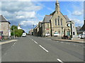
10
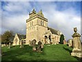
Chirnside Parish Church
Chirnside Parish Church lies on B6355, 6 miles east of Duns, in the Scottish Borders. World Champion Motor Racing Driver Jim Clark 1936-1968 was buried in the churchyard here. Jim died in April 1968 at the Hockenheim Circuit in Germany.
https://www.geograph.org.uk/photo/122202
Image: © Jennifer Petrie
Taken: 22 Oct 2017
0.07 miles