IMAGES TAKEN NEAR TO
DUNS, TD11 3TL
Introduction
This page details the photographs taken nearby to TD11 3TL by members of the Geograph project.
The Geograph project started in 2005 with the aim of publishing, organising and preserving representative images for every square kilometre of Great Britain, Ireland and the Isle of Man.

There are currently over 7.5m images from over14,400 individuals and you can help contribute to the project by visiting https://www.geograph.org.uk
Image Map (Loading...)


Getting Data...Please wait
Leaflet Map data © OpenStreetMap
Images are licensed for reuse under creativecommons.org/licenses/by-sa/2.0
Notes
- Clicking on the map will re-center to the selected point.
- The higher the marker number, the further away the image location is from the centre of the postcode.
Image Listing (7 Images Found)
Images are licensed for reuse under creativecommons.org/licenses/by-sa/2.0
Image
Details
Distance
2
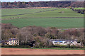
Primrosehill Farm
This farm at Preston was viewed from the B6365 near the access road to Castle Mains Farm.
Image: © Walter Baxter
Taken: 2 May 2016
0.03 miles
3
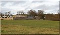
Primrosehill
Farm just outside Preston.
Image: © Richard Webb
Taken: 7 Jan 2007
0.06 miles
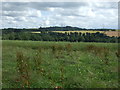
5
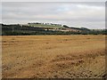
Stubble, Preston
Beside the Whiteadder Water.
Image: © Richard Webb
Taken: 20 Sep 2013
0.19 miles
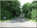
6
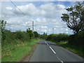
B6355 approaching Preston
Looking south east.
Image: © JThomas
Taken: 27 Jul 2017
0.22 miles
7
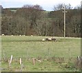
Primrosehill
Sheep grazing, and grabbing hay from the cratch below Primrosehill Farm.
Image: © Richard Webb
Taken: 7 Jan 2007
0.24 miles