IMAGES TAKEN NEAR TO
DUNS, TD11 3RB
Introduction
This page details the photographs taken nearby to TD11 3RB by members of the Geograph project.
The Geograph project started in 2005 with the aim of publishing, organising and preserving representative images for every square kilometre of Great Britain, Ireland and the Isle of Man.

There are currently over 7.5m images from over14,400 individuals and you can help contribute to the project by visiting https://www.geograph.org.uk
Image Map (11 Images)


Getting Data...Please wait
Leaflet Map data © OpenStreetMap
Images are licensed for reuse under creativecommons.org/licenses/by-sa/2.0
Notes
- Clicking on the map will re-center to the selected point.
- The higher the marker number, the further away the image location is from the centre of the postcode.
Image Listing (11 Images Found)
Images are licensed for reuse under creativecommons.org/licenses/by-sa/2.0
Image
Details
Distance
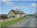
3
Fogorig
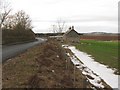
Main farm buildings to the left across the B6460.
Image: © Richard Webb
Taken: 3 Jan 2011
0.03 miles
4
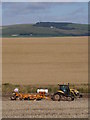
Disc Harrowing Oil Seed Rape Stubble
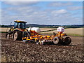
A Challenger tracked tractor and Simba disc harrow/cultivator in operation near Fogorig.
Image: © James T M Towill
Taken: 26 Aug 2012
0.05 miles
6
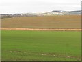
Winter crops, Fogorig
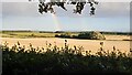
Looking towards the Lammermuir Hills.
Image: © Richard Webb
Taken: 3 Jan 2011
0.08 miles
9
Preparing The Land At Fogorig
Disc harrowing oil seed rape stubble near Fogorig with Hardens Hill in the far distance.
Image: © James T M Towill
Taken: 26 Aug 2012
0.13 miles
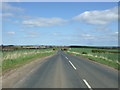
10
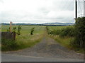
Fogorig
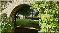
Footpath From Fogorig To Fogo
Image: © Douglas Banks
Taken: 12 Jul 2006
0.19 miles