IMAGES TAKEN NEAR TO
DUNS, TD11 3QA
Introduction
This page details the photographs taken nearby to TD11 3QA by members of the Geograph project.
The Geograph project started in 2005 with the aim of publishing, organising and preserving representative images for every square kilometre of Great Britain, Ireland and the Isle of Man.

There are currently over 7.5m images from over14,400 individuals and you can help contribute to the project by visiting https://www.geograph.org.uk
Image Map
Images are licensed for reuse under creativecommons.org/licenses/by-sa/2.0
Notes
- Clicking on the map will re-center to the selected point.
- The higher the marker number, the further away the image location is from the centre of the postcode.
Image Listing (16 Images Found)
Images are licensed for reuse under creativecommons.org/licenses/by-sa/2.0
Image
Details
Distance
1
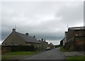
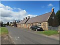
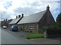
Lintlaw in Berwickshire
Buildings of Lintlaw Farm populate the right hand side of the photograph while a row of cottages occupy the other side. The road through the hamlet leads to Chirnside.
Image: © James Denham
Taken: 10 Jul 2015
0.10 miles
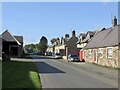
3
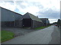
Lintlaw
The farm as seen from the south.
Image: © Richard Webb
Taken: 7 Jan 2007
0.12 miles
5
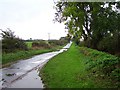
Lintlaw
Lintlaw is the farm at the end of this long straight section of road.
Image: © Richard Webb
Taken: 20 Oct 2006
0.12 miles
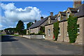
8
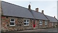
Cottages at Lintlaw - nos 11 & 12
Some of the houses at Lintlaw farm.
Image: © M J Richardson
Taken: 30 Aug 2023
0.13 miles
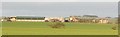
10
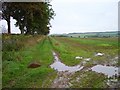
Stubble, Lintlaw
Wet stubble fields. The beeches mark a trackway over to Bunkle Kirk.
Image: © Richard Webb
Taken: 20 Oct 2006
0.14 miles