IMAGES TAKEN NEAR TO
DUNS, TD11 3PW
Introduction
This page details the photographs taken nearby to TD11 3PW by members of the Geograph project.
The Geograph project started in 2005 with the aim of publishing, organising and preserving representative images for every square kilometre of Great Britain, Ireland and the Isle of Man.

There are currently over 7.5m images from over14,400 individuals and you can help contribute to the project by visiting https://www.geograph.org.uk
Image Map (Loading...)


Getting Data...Please wait
Leaflet Map data © OpenStreetMap
Images are licensed for reuse under creativecommons.org/licenses/by-sa/2.0
Notes
- Clicking on the map will re-center to the selected point.
- The higher the marker number, the further away the image location is from the centre of the postcode.
Image Listing (7 Images Found)
Images are licensed for reuse under creativecommons.org/licenses/by-sa/2.0
Image
Details
Distance
1
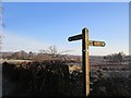
Footpath sign, Johnsfield
Sign with mixed farmland in the background. A farm road goes to Buxley via Broomfield.
Image: © Richard Webb
Taken: 26 Feb 2013
0.01 miles
2
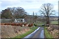
Minor road at Johnsfield
A quiet road in the farming country north of Duns. A footpath to Buxley heads to the right by the wall in the centre of the image.
Image: © Jim Barton
Taken: 6 Mar 2017
0.01 miles
3
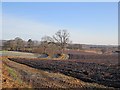
Frost by Johnsfield
A frosted ploughed field near Duns.
Image: © Richard Webb
Taken: 26 Feb 2013
0.04 miles
5
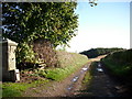
Track to Broomhill Farm.
Off the minor road at Johnsfield.
Image: © James Denham
Taken: 16 Oct 2008
0.06 miles
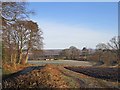
6
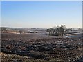
Arable land, Ladywell
Newly ploughed on a frosty morning.
Image: © Richard Webb
Taken: 26 Feb 2013
0.13 miles
7
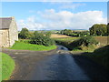
Road at entrance to Ladywell
Looking northward.
Image: © Peter Wood
Taken: 2 Oct 2016
0.24 miles