IMAGES TAKEN NEAR TO
Old Quarry Road, DUNS, TD11 3NH
Introduction
This page details the photographs taken nearby to Old Quarry Road, TD11 3NH by members of the Geograph project.
The Geograph project started in 2005 with the aim of publishing, organising and preserving representative images for every square kilometre of Great Britain, Ireland and the Isle of Man.

There are currently over 7.5m images from over14,400 individuals and you can help contribute to the project by visiting https://www.geograph.org.uk
Image Map
Images are licensed for reuse under creativecommons.org/licenses/by-sa/2.0
Notes
- Clicking on the map will re-center to the selected point.
- The higher the marker number, the further away the image location is from the centre of the postcode.
Image Listing (6 Images Found)
Images are licensed for reuse under creativecommons.org/licenses/by-sa/2.0
Image
Details
Distance
1
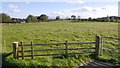
Field near Duns
It used to be the home of Image
Image: © Richard Webb
Taken: 30 Sep 2018
0.12 miles
2
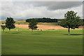
Duns Golf Course
Looking over the 1st fairway to golfers playing the 18th hole.
Image: © Walter Baxter
Taken: 29 Aug 2008
0.14 miles
3
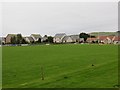
Duns Rugby Club
The pitch is almost part of a small housing estate.
Image: © Richard Webb
Taken: 13 Sep 2013
0.14 miles
4
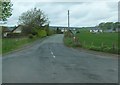
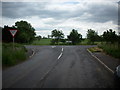
Minor road to Longformacus
At the junction on the A6105 at Pouterlany, southwest of Duns.
Image: © Barbara Carr
Taken: 27 May 2013
0.20 miles
5
Junction at Pouterlany
The minor road to Longformacus and the Lammermuirs beyond, leads off the A6105 here, near Duns
Image: © James Denham
Taken: 10 Jun 2008
0.20 miles
6
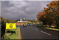
New speed limit ahead at Duns, Berwickshire
91 towns and villages in the Scottish Borders are having the 30mph speed limit reduced to 20mph as a result of the Scottish Borders Council Spaces for People trial. The purpose of the scheme is to make it easier and safer for the public to walk and cycle. Some stretches of road are being reduced from 60mph to 40mph and from 40mph to 30mph. The scheme will be reviewed after 12 to 18 months.
Image: © Walter Baxter
Taken: 10 Oct 2020
0.21 miles