IMAGES TAKEN NEAR TO
Bridgend, DUNS, TD11 3ER
Introduction
This page details the photographs taken nearby to Bridgend, TD11 3ER by members of the Geograph project.
The Geograph project started in 2005 with the aim of publishing, organising and preserving representative images for every square kilometre of Great Britain, Ireland and the Isle of Man.

There are currently over 7.5m images from over14,400 individuals and you can help contribute to the project by visiting https://www.geograph.org.uk
Image Map (Loading...)


Getting Data...Please wait
Leaflet Map data © OpenStreetMap
Images are licensed for reuse under creativecommons.org/licenses/by-sa/2.0
Notes
- Clicking on the map will re-center to the selected point.
- The higher the marker number, the further away the image location is from the centre of the postcode.
Image Listing (68 Images Found)
Images are licensed for reuse under creativecommons.org/licenses/by-sa/2.0
Image
Details
Distance
1
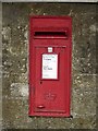
Postbox, Bridgend, Duns
A wall box located in the boundary wall of a residential property on Bridgend, Duns.
Image: © Graham Robson
Taken: 18 Sep 2014
0.09 miles
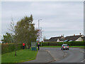
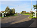
2
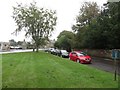
Bridgend, Duns
A short residential street in Duns accessed from Currie Street.
Image: © Graham Robson
Taken: 18 Sep 2014
0.10 miles
3
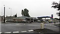
Independent garage, Duns
An independently owned garage and filling station at the junction of Currie Street and Bridgend. The roundabout at the road junction is in the foreground. The garage offers services for the repairing, refuelling and retailing of vehicles.
Image: © Graham Robson
Taken: 18 Sep 2014
0.11 miles
4
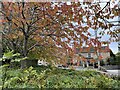
Autumn arrives in Duns
No bright sunshine but the cherry tree leaves were still colourful.
Image: © Jennifer Petrie
Taken: 9 Oct 2022
0.13 miles
5
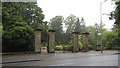
Entrance to Duns Public Park
The main entrance to Duns Public Park.
Image: © Graham Robson
Taken: 18 Sep 2014
0.14 miles
6
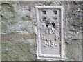
Ordnance Survey Flush Bracket 2434
This can be found on external wall of a house - a private dwelling - at Bridge End, Duns.
For more detail see : http://www.bench-marks.org.uk/bm712
Image: © Peter Wood
Taken: 1 Oct 2016
0.14 miles
7
A6105 east of Duns
The road to Chirnside and Berwick close to the edge of the town.
Image: © Jim Barton
Taken: 2 May 2023
0.15 miles
8
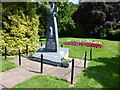
Polish Armoured Regiments Memorial
Memorial to Polish soldiers stationed in Duns 1941-44, who died in battle 1944-45. https://en.wikipedia.org/wiki/1st_Armoured_Division_(Poland) It was unveiled by General Stanislaw Maczek on 13th September 1991. Note the flower bed in the colours of Poland's national flag.
Image: © kim traynor
Taken: 22 Jul 2014
0.16 miles
9
Road (A6105) at Bridge End in Duns
Looking north-eastward.
Image: © Peter Wood
Taken: 1 Oct 2016
0.16 miles
10
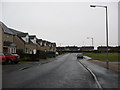
Newer housing in Duns
In Berwickshire.
Image: © James Denham
Taken: 16 Feb 2009
0.16 miles