IMAGES TAKEN NEAR TO
Harp Road, HIGHBRIDGE, TA9 4QW
Introduction
This page details the photographs taken nearby to Harp Road, TA9 4QW by members of the Geograph project.
The Geograph project started in 2005 with the aim of publishing, organising and preserving representative images for every square kilometre of Great Britain, Ireland and the Isle of Man.

There are currently over 7.5m images from over14,400 individuals and you can help contribute to the project by visiting https://www.geograph.org.uk
Image Map
Images are licensed for reuse under creativecommons.org/licenses/by-sa/2.0
Notes
- Clicking on the map will re-center to the selected point.
- The higher the marker number, the further away the image location is from the centre of the postcode.
Image Listing (3 Images Found)
Images are licensed for reuse under creativecommons.org/licenses/by-sa/2.0
Image
Details
Distance
1
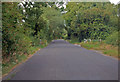
Harp road
The junction with Northwick Road can just be seen on the right.
Image: © J.Hannan-Briggs
Taken: 31 Jul 2014
0.06 miles
2
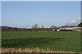
Field with Crooks Peak on the right in the background
Image: © Adrian and Janet Quantock
Taken: 14 Jan 2006
0.18 miles