IMAGES TAKEN NEAR TO
Poplar Lane, HIGHBRIDGE, TA9 4QU
Introduction
This page details the photographs taken nearby to Poplar Lane, TA9 4QU by members of the Geograph project.
The Geograph project started in 2005 with the aim of publishing, organising and preserving representative images for every square kilometre of Great Britain, Ireland and the Isle of Man.

There are currently over 7.5m images from over14,400 individuals and you can help contribute to the project by visiting https://www.geograph.org.uk
Image Map (Loading...)


Getting Data...Please wait
Leaflet Map data © OpenStreetMap
Images are licensed for reuse under creativecommons.org/licenses/by-sa/2.0
Notes
- Clicking on the map will re-center to the selected point.
- The higher the marker number, the further away the image location is from the centre of the postcode.
Image Listing (4 Images Found)
Images are licensed for reuse under creativecommons.org/licenses/by-sa/2.0
Image
Details
Distance
2
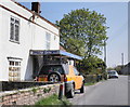
By Southwick Road
The road is accompanied by a rhyne on each side. The prominent house on the left is on the B3139 at the west end of Mark Causeway, the B3139.
Image: © Derek Harper
Taken: 13 Mar 2016
0.19 miles
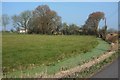
3
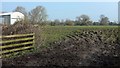
Field by Southwick Road
With a building at Upper Southwick Farm on the left.
Image: © Derek Harper
Taken: 13 Mar 2016
0.20 miles
4
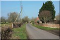
Southwick Road
The road from the junction shown in Image] to Mark Causeway passes the C18 Upper Southwick Farm, which is described at https://www.historicengland.org.uk/listing/the-list/list-entry/1262396 .
Image: © Derek Harper
Taken: 13 Mar 2016
0.25 miles