IMAGES TAKEN NEAR TO
The Causeway, HIGHBRIDGE, TA9 4QQ
Introduction
This page details the photographs taken nearby to The Causeway, TA9 4QQ by members of the Geograph project.
The Geograph project started in 2005 with the aim of publishing, organising and preserving representative images for every square kilometre of Great Britain, Ireland and the Isle of Man.

There are currently over 7.5m images from over14,400 individuals and you can help contribute to the project by visiting https://www.geograph.org.uk
Image Map
Images are licensed for reuse under creativecommons.org/licenses/by-sa/2.0
Notes
- Clicking on the map will re-center to the selected point.
- The higher the marker number, the further away the image location is from the centre of the postcode.
Image Listing (6 Images Found)
Images are licensed for reuse under creativecommons.org/licenses/by-sa/2.0
Image
Details
Distance
1
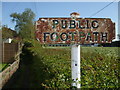
Footpath to Green Drove
This ancient sign looks like it has had a few licks of paint over the years.
Image: © Neil Owen
Taken: 11 May 2019
0.01 miles
3
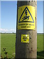
The latest in warnings
In addition to the usual hazards, the very latest addition to the pole concerns the twenty-first century essential. No village need be left out of the digital world now.
Image: © Neil Owen
Taken: 11 May 2019
0.09 miles
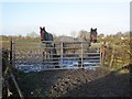
4
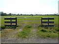
Short armco
These two lengths of barrier flanking the gate must be some of the shortest around. They help prevent entry into the ditches that are right around the field.
Image: © Neil Owen
Taken: 11 May 2019
0.19 miles
6
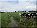
Cattle and drain
Looking towards Court Farm (the white building on the left).
Image: © Jonathan Thacker
Taken: 15 Sep 2015
0.24 miles