IMAGES TAKEN NEAR TO
Southwick, HIGHBRIDGE, TA9 4LJ
Introduction
This page details the photographs taken nearby to Southwick, TA9 4LJ by members of the Geograph project.
The Geograph project started in 2005 with the aim of publishing, organising and preserving representative images for every square kilometre of Great Britain, Ireland and the Isle of Man.

There are currently over 7.5m images from over14,400 individuals and you can help contribute to the project by visiting https://www.geograph.org.uk
Image Map (Loading...)


Getting Data...Please wait
Leaflet Map data © OpenStreetMap
Images are licensed for reuse under creativecommons.org/licenses/by-sa/2.0
Notes
- Clicking on the map will re-center to the selected point.
- The higher the marker number, the further away the image location is from the centre of the postcode.
Image Listing (6 Images Found)
Images are licensed for reuse under creativecommons.org/licenses/by-sa/2.0
Image
Details
Distance
1
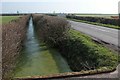
Rhyne by Southwick Road
Image: © Derek Harper
Taken: 13 Mar 2016
0.03 miles
2
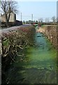
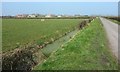
Rhyne by Southwick Road
From a new entrance to Southwick Farm (Image]), with the road on the left leading past Knowle View Farm.
Image: © Derek Harper
Taken: 13 Mar 2016
0.05 miles
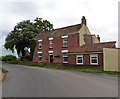
5
Southwick Farm
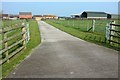
A fairly recently-created entrance to the farm from Southwick Road.
Image: © Derek Harper
Taken: 13 Mar 2016
0.10 miles
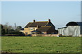
6
Mark Moor
Towards Knowle View Farm and Southwick Farm from the no through road shown in Image
Image: © Derek Harper
Taken: 13 Mar 2016
0.17 miles