IMAGES TAKEN NEAR TO
Poples Bow, HIGHBRIDGE, TA9 4EZ
Introduction
This page details the photographs taken nearby to Poples Bow, TA9 4EZ by members of the Geograph project.
The Geograph project started in 2005 with the aim of publishing, organising and preserving representative images for every square kilometre of Great Britain, Ireland and the Isle of Man.

There are currently over 7.5m images from over14,400 individuals and you can help contribute to the project by visiting https://www.geograph.org.uk
Image Map (Loading...)


Getting Data...Please wait
Leaflet Map data © OpenStreetMap
Images are licensed for reuse under creativecommons.org/licenses/by-sa/2.0
Notes
- Clicking on the map will re-center to the selected point.
- The higher the marker number, the further away the image location is from the centre of the postcode.
Image Listing (34 Images Found)
Images are licensed for reuse under creativecommons.org/licenses/by-sa/2.0
Image
Details
Distance
1
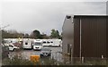
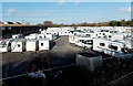
Highbridge Caravan Centre
Caravan, motorhome and camping dealers viewed across the A38 Bristol Road.
Image: © Jaggery
Taken: 10 Dec 2014
0.04 miles
2
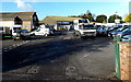
Highbridge Caravan Centre entrance
From the A38 Bristol Road.
Image: © Jaggery
Taken: 10 Dec 2014
0.05 miles
4
West side of Highbridge Caravan Centre
Caravan, motorhome and camping dealers viewed from the A38 Bristol Road.
Image: © Jaggery
Taken: 10 Dec 2014
0.08 miles
5
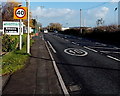
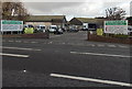
Start of the 40mph speed limit along the A38 Bristol Road, Highbridge
The 30mph speed limit in central Highbridge increases to 40mph
near the entrance http://www.geograph.org.uk/photo/4462980 to Highbridge Caravan Centre.
Image: © Jaggery
Taken: 10 Dec 2014
0.08 miles
6
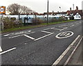
From 40 to 30 on Bristol Road, Highbridge
The 40mph speed limit on the A38 Bristol Road drops to 30 on the approach to central Highbridge.
Bristol Bridge Inn http://www.geograph.org.uk/photo/4275794 is in the background.
Image: © Jaggery
Taken: 10 Dec 2014
0.09 miles
7
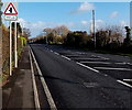
Minor road junction ahead, Bristol Road, Highbridge
On the approach to the Poples Bow junction http://www.geograph.org.uk/photo/4275901
Image: © Jaggery
Taken: 10 Dec 2014
0.10 miles
8
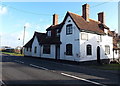
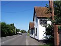
Bristol Bridge Inn, Highbridge
Viewed across the A38 Bristol Road.
Image: © Jaggery
Taken: 10 Dec 2014
0.10 miles
9
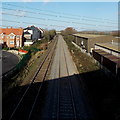
Railway north from Bristol Bridge, Highbridge
The Taunton to Bristol line viewed from this http://www.geograph.org.uk/photo/4462924 footbridge alongside
Bristol Bridge 750 metres north of Highbridge and Burnham railway station
Image: © Jaggery
Taken: 10 Dec 2014
0.10 miles