IMAGES TAKEN NEAR TO
Battleborough Lane, HIGHBRIDGE, TA9 4DS
Introduction
This page details the photographs taken nearby to Battleborough Lane, TA9 4DS by members of the Geograph project.
The Geograph project started in 2005 with the aim of publishing, organising and preserving representative images for every square kilometre of Great Britain, Ireland and the Isle of Man.

There are currently over 7.5m images from over14,400 individuals and you can help contribute to the project by visiting https://www.geograph.org.uk
Image Map
Images are licensed for reuse under creativecommons.org/licenses/by-sa/2.0
Notes
- Clicking on the map will re-center to the selected point.
- The higher the marker number, the further away the image location is from the centre of the postcode.
Image Listing (7 Images Found)
Images are licensed for reuse under creativecommons.org/licenses/by-sa/2.0
Image
Details
Distance
1
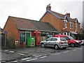
Village Post Office and stores, Brent Knoll
Image: © Roger Cornfoot
Taken: 19 Feb 2014
0.07 miles
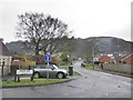
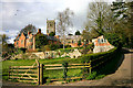
3

Towards Brent Knoll
From the A38 near Battleborough.
Image: © Derek Harper
Taken: 30 Aug 2016
0.22 miles
4
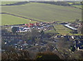
New homes in Brent Knoll
Some heavy plant has made a start on some extra homes in the village.
Image: © Neil Owen
Taken: 5 Jan 2017
0.23 miles
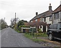
7
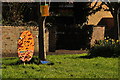
Brent Knoll : Grass Verge
Between the road and the pavement there is something eggstra terrestrial.
Image: © Lewis Clarke
Taken: 6 Apr 2015
0.25 miles