IMAGES TAKEN NEAR TO
Dairy Court, TA9 3NE
Introduction
This page details the photographs taken nearby to Dairy Court, TA9 3NE by members of the Geograph project.
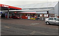
The Geograph project started in 2005 with the aim of publishing, organising and preserving representative images for every square kilometre of Great Britain, Ireland and the Isle of Man.

There are currently over 7.5m images from over14,400 individuals and you can help contribute to the project by visiting https://www.geograph.org.uk
Image Map
Images are licensed for reuse under creativecommons.org/licenses/by-sa/2.0
Notes
- Clicking on the map will re-center to the selected point.
- The higher the marker number, the further away the image location is from the centre of the postcode.
Image Listing (97 Images Found)
Images are licensed for reuse under creativecommons.org/licenses/by-sa/2.0
Image
Details
Distance
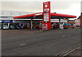
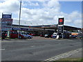
1
Highbridge Spar
The Spar shop is at the back of this http://www.geograph.org.uk/photo/4287902 Murco filling station on the south side of Huntspill Road.
Image: © Jaggery
Taken: 10 Dec 2014
0.12 miles
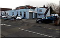
2
Entrance to Premier Business Park, Highbridge
From the south side of the A38 Huntspill Road. Behind the cars,
a large white board lists the businesses in the park.
Image: © Jaggery
Taken: 10 Dec 2014
0.12 miles
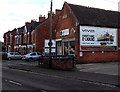
3

Ideal Cars Southwest, Highbridge
Used car dealer located in Buncombes Garage, Huntspill Road, alongside a Murco filling station.
Image: © Jaggery
Taken: 10 Dec 2014
0.12 miles
4
Alstone : Murco
A Murco petrol station on Huntspill Road.
Image: © Lewis Clarke
Taken: 24 Feb 2018
0.13 miles
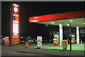
5
Murco filling station in Highbridge
On the south side of the A38 Huntspill Road. Ideal Cars Southwest http://www.geograph.org.uk/photo/4287890 is on the left.
Image: © Jaggery
Taken: 10 Dec 2014
0.13 miles
7
Vivid advert in Highbridge
Viewed across the A38 Huntspill Road. An advert for Vivid (for everything e-liquid)
is on the wall of a former Baptist Congregational Church, now SAS garage. http://www.geograph.org.uk/photo/4287991
Image: © Jaggery
Taken: 10 Dec 2014
0.13 miles
8
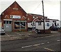
SAS garage in Highbridge
Viewed across the A38 Huntspill Road. SAS on the left is a car and light commercial vehicle repairs & servicing business located in the former Baptist Congregational Church which opened in 1895.
Image: © Jaggery
Taken: 10 Dec 2014
0.13 miles
9
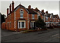
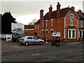
Huntspill Road houses in Highbridge
The corner house is alongside the entrance road to Premier Business Park.
Image: © Jaggery
Taken: 10 Dec 2014
0.13 miles
10
Priory Cars in Highbridge
Car sales business in the former West of England Creamery on the south side of the A38 Huntspill Road.
The other side of the building is occupied by Curtain Call School of Performing Arts. http://www.geograph.org.uk/photo/4288002
Image: © Jaggery
Taken: 10 Dec 2014
0.13 miles