IMAGES TAKEN NEAR TO
Adams Close, HIGHBRIDGE, TA9 3DX
Introduction
This page details the photographs taken nearby to Adams Close, TA9 3DX by members of the Geograph project.
The Geograph project started in 2005 with the aim of publishing, organising and preserving representative images for every square kilometre of Great Britain, Ireland and the Isle of Man.

There are currently over 7.5m images from over14,400 individuals and you can help contribute to the project by visiting https://www.geograph.org.uk
Image Map
Images are licensed for reuse under creativecommons.org/licenses/by-sa/2.0
Notes
- Clicking on the map will re-center to the selected point.
- The higher the marker number, the further away the image location is from the centre of the postcode.
Image Listing (55 Images Found)
Images are licensed for reuse under creativecommons.org/licenses/by-sa/2.0
Image
Details
Distance
1
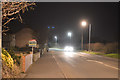
Alstone : Huntspill Road A38
Looking along Huntspill Road.
Image: © Lewis Clarke
Taken: 24 Feb 2018
0.04 miles
2
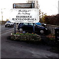
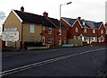
Thankyou for visiting Highbridge Burnham-on-Sea
The sign is alongside the A38 Huntspill Road at the southern edge of Highbridge. It shows twinned with Fritzlar (in Germany) & Louvigné-du-Désert (in Brittany in NW France) and Friendship Link with Cassis (in southern France).
Image: © Jaggery
Taken: 10 Dec 2014
0.05 miles
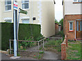
3
Welcome to Highbridge Burnham-on-Sea
The Welcome sign is alongside the A38 Huntspill Road at the southern edge of Highbridge.
Image: © Jaggery
Taken: 10 Dec 2014
0.05 miles
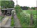
6
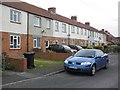
Alstone : Meadow View
Looking into Meadow View in Alstone off of Huntspill Road.
Image: © Lewis Clarke
Taken: 24 Feb 2018
0.06 miles

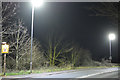
8
Alstone : Huntspill Road A38
Looking along Huntspill Road in Alstone.
Image: © Lewis Clarke
Taken: 24 Feb 2018
0.08 miles