IMAGES TAKEN NEAR TO
Poplar Estate, HIGHBRIDGE, TA9 3AP
Introduction
This page details the photographs taken nearby to Poplar Estate, TA9 3AP by members of the Geograph project.
The Geograph project started in 2005 with the aim of publishing, organising and preserving representative images for every square kilometre of Great Britain, Ireland and the Isle of Man.

There are currently over 7.5m images from over14,400 individuals and you can help contribute to the project by visiting https://www.geograph.org.uk
Image Map
Images are licensed for reuse under creativecommons.org/licenses/by-sa/2.0
Notes
- Clicking on the map will re-center to the selected point.
- The higher the marker number, the further away the image location is from the centre of the postcode.
Image Listing (147 Images Found)
Images are licensed for reuse under creativecommons.org/licenses/by-sa/2.0
Image
Details
Distance
1
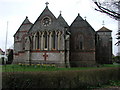
HIGHBRIDGE, Somerset
The church of St John the Evangelist, now shorn of its tower and spire.
Image: © ChurchCrawler
Taken: 4 Mar 2004
0.09 miles
2
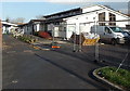
Highbridge Children's Centre
On the north side of Coronation Road, near Churchfield primary school and the Poplar Estate.
Image: © Jaggery
Taken: 10 Dec 2014
0.09 miles
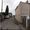
3
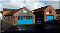
Auto Body Mechanical in Highbridge
Accident repairs, respraying and welding garage in Coronation Road.
Image: © Jaggery
Taken: 10 Dec 2014
0.10 miles
4
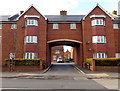
Entrance to Foster Court, Highbridge
Flats on the west side of Church Street.
Image: © Jaggery
Taken: 10 Dec 2014
0.10 miles
5
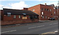
Highbridge Social Club
At 95 Church Street, opposite Grange Avenue.
Image: © Jaggery
Taken: 10 Dec 2014
0.10 miles
6
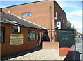
Highbridge Social Club
The club was founded in 1914 and holds lots of local entertainment and functions throughout the year. It is also home to the local football team.
Image: © Neil Owen
Taken: 13 Aug 2013
0.10 miles
7
Kings Street towards CJK vehicle repairs in Highbridge
A CJK van is parked at the edge of The Yard, the premises of CJK Vehicle Repairs Ltd.
A notice on the fence on the right shows that parking is reserved for residents only. Unauthorised vehicles will be clamped.
Image: © Jaggery
Taken: 10 Dec 2014
0.11 miles
8
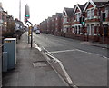
Pelican crossing, Church Street, Highbridge
A pelican crossing is the type of pedestrian-operated street crossing seen here.
Chambers Dictionary states that "pelican" is adapted from "pedestrian light controlled crossing".
The lights do not usually change to red as soon as a pedestrian presses the button on the control box.
It seems to me that in moderately heavy traffic, the lights often don't change to red until a largish gap in traffic appears...
Image: © Jaggery
Taken: 10 Dec 2014
0.11 miles
9
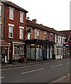
Bay Tree Upholstery & Beds in Highbridge
Church Street shop near the corner of Grange Avenue.
Image: © Jaggery
Taken: 10 Dec 2014
0.11 miles
10
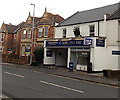
Rob's Fish Bar in Highbridge
Fish & chips takeaway at 28 Church Street.
Image: © Jaggery
Taken: 10 Dec 2014
0.12 miles