IMAGES TAKEN NEAR TO
Wilton Close, BURNHAM-ON-SEA, TA8 2UB
Introduction
This page details the photographs taken nearby to Wilton Close, TA8 2UB by members of the Geograph project.
The Geograph project started in 2005 with the aim of publishing, organising and preserving representative images for every square kilometre of Great Britain, Ireland and the Isle of Man.

There are currently over 7.5m images from over14,400 individuals and you can help contribute to the project by visiting https://www.geograph.org.uk
Image Map (Loading...)


Getting Data...Please wait
Leaflet Map data © OpenStreetMap
Images are licensed for reuse under creativecommons.org/licenses/by-sa/2.0
Notes
- Clicking on the map will re-center to the selected point.
- The higher the marker number, the further away the image location is from the centre of the postcode.
Image Listing (6 Images Found)
Images are licensed for reuse under creativecommons.org/licenses/by-sa/2.0
Image
Details
Distance
1
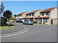
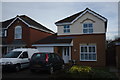
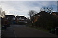
Barrington Rd Burnham on Sea
A new housing development on the eastern edge of the town.
Image: © Nigel Mykura
Taken: Unknown
0.01 miles
2
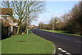
Love Lane heading towards Middle Burnham
Image: © Adrian and Janet Quantock
Taken: 14 Jan 2006
0.04 miles
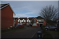
4
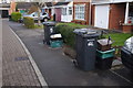
Official eyesores
Wedmore operates a sorted recycling scheme, with compartmentised lorries. The home owners have to put out this lot every week.
Image: © Bob Harvey
Taken: 19 Dec 2017
0.19 miles