IMAGES TAKEN NEAR TO
Gielgud Close, BURNHAM-ON-SEA, TA8 1RH
Introduction
This page details the photographs taken nearby to Gielgud Close, TA8 1RH by members of the Geograph project.
The Geograph project started in 2005 with the aim of publishing, organising and preserving representative images for every square kilometre of Great Britain, Ireland and the Isle of Man.

There are currently over 7.5m images from over14,400 individuals and you can help contribute to the project by visiting https://www.geograph.org.uk
Image Map
Images are licensed for reuse under creativecommons.org/licenses/by-sa/2.0
Notes
- Clicking on the map will re-center to the selected point.
- The higher the marker number, the further away the image location is from the centre of the postcode.
Image Listing (7 Images Found)
Images are licensed for reuse under creativecommons.org/licenses/by-sa/2.0
Image
Details
Distance
1
Rhyne off the Frank Foley Parkway
Image: © Adrian and Janet Quantock
Taken: 14 Jan 2006
0.04 miles
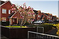
2
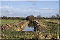
New housing, Burnham on Sea
This new development is on Burnham level, very flat land to the east of the town. A lot of this land is only 5 or 6 metres above sea level and may be susceptible to flooding
Image: © Nigel Mykura
Taken: 10 Jun 2008
0.11 miles
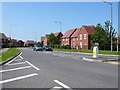
3
Burnham-on-Sea : Ben Travers Way
A road heading through the suburbs of Burnham-on-Sea.
Image: © Lewis Clarke
Taken: 6 Apr 2015
0.19 miles
4
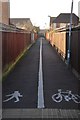
Burnham-on-Sea : Footpath
A footpath heading from Ben Travers Way to Ashcott Close.
Image: © Lewis Clarke
Taken: 6 Apr 2015
0.19 miles
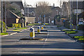
5
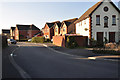
Burnham-on-Sea : Olivier Close
A small residential road off of Ben Travers Way.
Image: © Lewis Clarke
Taken: 6 Apr 2015
0.21 miles
6
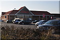
Burnham-on-Sea : Tesco Superstore
Looking towards Tesco from The Frank Foley Parkway.
Image: © Lewis Clarke
Taken: 6 Apr 2015
0.23 miles
7
Burnham-on-Sea : Olivier Close
Looking along Olivier Close from the path beside it.
Image: © Lewis Clarke
Taken: 6 Apr 2015
0.24 miles