IMAGES TAKEN NEAR TO
Gloucester Road, BURNHAM-ON-SEA, TA8 1JA
Introduction
This page details the photographs taken nearby to Gloucester Road, TA8 1JA by members of the Geograph project.
The Geograph project started in 2005 with the aim of publishing, organising and preserving representative images for every square kilometre of Great Britain, Ireland and the Isle of Man.

There are currently over 7.5m images from over14,400 individuals and you can help contribute to the project by visiting https://www.geograph.org.uk
Image Map (Loading...)


Getting Data...Please wait
Leaflet Map data © OpenStreetMap
Images are licensed for reuse under creativecommons.org/licenses/by-sa/2.0
Notes
- Clicking on the map will re-center to the selected point.
- The higher the marker number, the further away the image location is from the centre of the postcode.
Image Listing (8 Images Found)
Images are licensed for reuse under creativecommons.org/licenses/by-sa/2.0
Image
Details
Distance
1
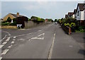
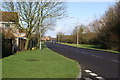
Westfield Road, Burnham-on-Sea
Looking east along Westfield Road. The Westfield Drive junction is on the left.
Image: © Jaggery
Taken: 12 May 2016
0.20 miles
2
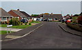
Barrington Rd Burnham on Sea
A new housing development on the eastern edge of the town.
Image: © Nigel Mykura
Taken: Unknown
0.22 miles
3
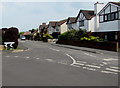
Westfield Road houses, Burnham-on-Sea
Viewed from the corner of Westfield Drive looking east.
Image: © Jaggery
Taken: 12 May 2016
0.23 miles
4
Love Lane heading towards Middle Burnham
Image: © Adrian and Janet Quantock
Taken: 14 Jan 2006
0.23 miles
5
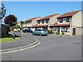
Westfield Close, Burnham-on-Sea
Cul-de-sac of bungalows on the east side of Westfield Drive.
Image: © Jaggery
Taken: 12 May 2016
0.23 miles
6

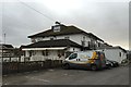
Burnham-on-Sea Carnival 2015
The oncoming float was created by the Eclipse Carnival Club of Chard, and is on the theme of 'Madagascar', the animated comedy film franchise from Dreamworks.
The full title of this event is Highbridge and Burnham-on-Sea Guy Fawkes Carnival.
Image: © Jonathan Hutchins
Taken: 9 Nov 2015
0.24 miles
7
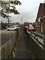
Burnham-on-Sea: public footpath off Love Lane
This footpath runs in a dead straight line from Love Lane to the cemetery, crossing St Paul's Road and St John's Road en route.
Image: © Jonathan Hutchins
Taken: 9 Nov 2015
0.24 miles