IMAGES TAKEN NEAR TO
Bradley Lane, BRIDGWATER, TA7 9RD
Introduction
This page details the photographs taken nearby to Bradley Lane, TA7 9RD by members of the Geograph project.
The Geograph project started in 2005 with the aim of publishing, organising and preserving representative images for every square kilometre of Great Britain, Ireland and the Isle of Man.

There are currently over 7.5m images from over14,400 individuals and you can help contribute to the project by visiting https://www.geograph.org.uk
Image Map
Images are licensed for reuse under creativecommons.org/licenses/by-sa/2.0
Notes
- Clicking on the map will re-center to the selected point.
- The higher the marker number, the further away the image location is from the centre of the postcode.
Image Listing (15 Images Found)
Images are licensed for reuse under creativecommons.org/licenses/by-sa/2.0
Image
Details
Distance
1
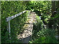
Footbridge south of Ashcott
Fortunately provided with one rail, for part of the traverse.
Image: © Neil Owen
Taken: 26 Apr 2021
0.08 miles
2
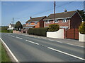
Lost on the A361
This handful of houses lining the A361 are missing a milestone that used to stand in front of the white walls - but no longer. However, someone a few doors down has recreated the roadside relic - see Image
Image: © Neil Owen
Taken: 26 Apr 2021
0.09 miles
3
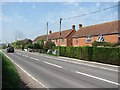
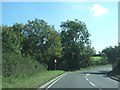
Taunton Road
The A361 south of Ashcott.
Image: © Richard Webb
Taken: 21 Apr 2011
0.10 miles
4
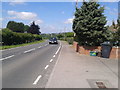
Car on the A361, heading towards Ashcott
Image: © Rob Purvis
Taken: 18 Jun 2015
0.10 miles
5
Junction of Norman Lane with A39
Norman Lane leads south-east from Ashcott to join the A39 at this bend; the road is one-way with no entry from the A39.
Image: © David Smith
Taken: 28 Sep 2011
0.10 miles
6
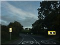
A39 Entering Ashcott
With the 30 limit starting.
Image: © Steve Barnes
Taken: 25 Aug 2009
0.10 miles
7
A tribute to a milestone
The A361 rushes past a handful of houses: once there was a milestone a little further up the road, which has now been lost. Undeterred, someone has made a sign to honour it - see Image
Image: © Neil Owen
Taken: 26 Apr 2021
0.11 miles
8
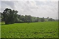
Sedgemoor : Grassy Fields
Looking out from the A39 towards the grassy Somerset fields.
Image: © Lewis Clarke
Taken: 15 Jun 2012
0.11 miles
9
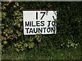
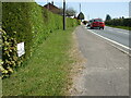
A helpful hint to travellers
This hand-made sign indicates the distance to the county town of Somerset. Notably, it is a modern appreciation of an original milestone that used to stand nearby. See Image] for a wider view.
Image: © Neil Owen
Taken: 26 Apr 2021
0.11 miles
10
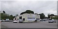
Car wash company
Presumably this was formerly a service station
Image: © David Smith
Taken: 10 Jun 2017
0.13 miles