IMAGES TAKEN NEAR TO
Broadmead Lane, BRIDGWATER, TA7 9JZ
Introduction
This page details the photographs taken nearby to Broadmead Lane, TA7 9JZ by members of the Geograph project.
The Geograph project started in 2005 with the aim of publishing, organising and preserving representative images for every square kilometre of Great Britain, Ireland and the Isle of Man.

There are currently over 7.5m images from over14,400 individuals and you can help contribute to the project by visiting https://www.geograph.org.uk
Image Map
Images are licensed for reuse under creativecommons.org/licenses/by-sa/2.0
Notes
- Clicking on the map will re-center to the selected point.
- The higher the marker number, the further away the image location is from the centre of the postcode.
Image Listing (14 Images Found)
Images are licensed for reuse under creativecommons.org/licenses/by-sa/2.0
Image
Details
Distance
1
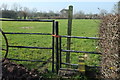
Footpath by Broadmead Lane
Footpath BW 14/7 leaves the lane over this stile. See Image] for the footpath on the other side of the lane.
Image: © Derek Harper
Taken: 13 Mar 2016
0.02 miles
2
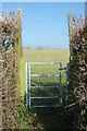
Footpath by Broadmead Lane
Footpath BW 14/7 leaves the lane through this gate, on the other side from Image
Image: © Derek Harper
Taken: 13 Mar 2016
0.03 miles
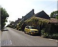
3
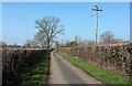
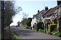
Broadmead Lane
A tiny wandering lane north of Edington, seen here near Corndean Farm.
Image: © Derek Harper
Taken: 13 Mar 2016
0.06 miles
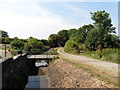
9
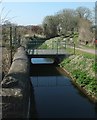
Nidon Rhyne
Seen from Nidon Bridge, with a footbridge just 15 metres away. Moorclose Drove is on the right, followed by footpath BW 14/12.
Image: © Derek Harper
Taken: 13 Mar 2016
0.18 miles
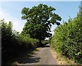
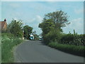
10
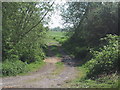
Track leaves the road near Edington
Image: © Sarah Charlesworth
Taken: 13 May 2010
0.20 miles