IMAGES TAKEN NEAR TO
New Road, BRIDGWATER, TA7 8PT
Introduction
This page details the photographs taken nearby to New Road, TA7 8PT by members of the Geograph project.
The Geograph project started in 2005 with the aim of publishing, organising and preserving representative images for every square kilometre of Great Britain, Ireland and the Isle of Man.

There are currently over 7.5m images from over14,400 individuals and you can help contribute to the project by visiting https://www.geograph.org.uk
Image Map
Images are licensed for reuse under creativecommons.org/licenses/by-sa/2.0
Notes
- Clicking on the map will re-center to the selected point.
- The higher the marker number, the further away the image location is from the centre of the postcode.
Image Listing (56 Images Found)
Images are licensed for reuse under creativecommons.org/licenses/by-sa/2.0
Image
Details
Distance
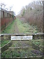
2
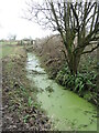
Rhyne by Little Wall Lane
A drainage ditch runs parallel with the old railway embankment and is rather covered with weed. It is a re-routed ditch as it was dug once the line was built in the nineteenth century.
Image: © Neil Owen
Taken: 26 Jan 2023
0.10 miles
3
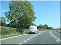
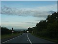
Knowle
The A39 just touches the north west corner of the square. This is the view south east from Just south of the main road.
Image: © Nigel Mykura
Taken: 6 Jan 2010
0.10 miles
4
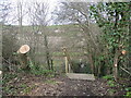
Felling on the old railway embankment
The old Somerset and Dorset Joint Railway Bridgwater branch line was built across the north of Bawdrip from the late nineteenth century and lasted into the post-war era before closure. Now the tracks have been torn up, the line is still partly navigable as a footpath. However, some sections are regrowing rapidly and some work is needed to clear the timber. The path runs across the embankment to the other side via steps.
Image: © Neil Owen
Taken: 26 Jan 2023
0.11 miles
5

Ploughed field near Bawdrip
This must be the field shown in Image, seen from the top of Bawdrip Lane. The A39 is on the right.
Image: © Derek Harper
Taken: 13 Mar 2016
0.11 miles
7
The land beyond
A short sliver of land between the old railway embankment and the new houses is owned by the village. Judging by the muddy trail, it seems to be a popular route.
Image: © Neil Owen
Taken: 26 Jan 2023
0.13 miles
8
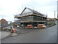
New build on New Lane
Bawdrip has expanded a lot in recent years, with many new houses swelling the population to around 500. An old farm building has been demolished and yet more houses are going up in its stead.
Image: © Neil Owen
Taken: 26 Jan 2023
0.14 miles
9
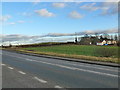
The A 39 Bath Road from lay-by, close to Bawdrip, Somerset
Image: © Ruth Sharville
Taken: 15 Feb 2012
0.14 miles
10
Cattle Crossing on the A39
Hopefully the Farmer is in control of these lights on the A39.
Image: © Steve Barnes
Taken: 25 Aug 2009
0.14 miles