IMAGES TAKEN NEAR TO
Burtle, BRIDGWATER, TA7 8ND
Introduction
This page details the photographs taken nearby to TA7 8ND by members of the Geograph project.
The Geograph project started in 2005 with the aim of publishing, organising and preserving representative images for every square kilometre of Great Britain, Ireland and the Isle of Man.

There are currently over 7.5m images from over14,400 individuals and you can help contribute to the project by visiting https://www.geograph.org.uk
Image Map
Images are licensed for reuse under creativecommons.org/licenses/by-sa/2.0
Notes
- Clicking on the map will re-center to the selected point.
- The higher the marker number, the further away the image location is from the centre of the postcode.
Image Listing (11 Images Found)
Images are licensed for reuse under creativecommons.org/licenses/by-sa/2.0
Image
Details
Distance
1
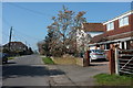
Burtle Road
Looking away from the junction where Image was taken.
Image: © Derek Harper
Taken: 13 Mar 2016
0.02 miles
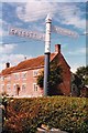
2
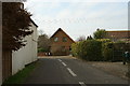
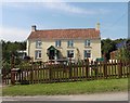
House
"Pethram Garden" on Westhay Broad Drove in Burtle.
Image: © Adrian and Janet Quantock
Taken: 5 Feb 2006
0.03 miles
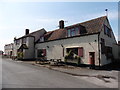
3
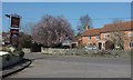
Farmhouse, Burtle
Watts Farm is opposite the Burtle Inn, whose sign is on the left. In between, some pretty blossom - cherry, I assume.
Image: © Derek Harper
Taken: 13 Mar 2016
0.04 miles
4
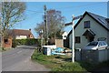
Signpost, Burtle
At the junction of Westhay Broad Drove and Catcott Broad Drove, which is also where Image was taken.
Image: © Derek Harper
Taken: 13 Mar 2016
0.05 miles
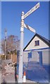
5
Direction Sign ? Signpost
Located on the southeast side of the junction of Burtle Road, Catcott Broad Drove and Westhay Broad Drove in Burtle parish. 2 arms and pyramid finial. An older photo of https://www.geograph.org.uk/photo/6068890. See also http://www.geograph.org.uk/photo/4995487.
Milestone Society National ID: SO_ST4043
Image: © W Marsh
Taken: Unknown
0.05 miles
6
Old Direction Sign - Signpost by Catcott Broad Drove, Burtle
Pyramid finial - 2 arms; Somerset SCC pyramid by the UC road, in parish of Burtle (Sedgemoor District), Burtle Road junction with Catcott Broad Drove and Westhay Broad Drove.
Surveyed
Milestone Society National ID: SO_ST4043
Image: © Milestone Society
Taken: Unknown
0.05 miles
8
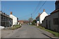
Burtle
Approaching the junction where Image] was taken along Catcott Broad Drove.
Image: © Derek Harper
Taken: 13 Mar 2016
0.06 miles
10
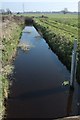
Huntspill Drove Rhyne
From Catcott Broad Drove.
Image: © Derek Harper
Taken: 13 Mar 2016
0.14 miles