IMAGES TAKEN NEAR TO
Sedgemoor Way, BRIDGWATER, TA7 8JF
Introduction
This page details the photographs taken nearby to Sedgemoor Way, TA7 8JF by members of the Geograph project.
The Geograph project started in 2005 with the aim of publishing, organising and preserving representative images for every square kilometre of Great Britain, Ireland and the Isle of Man.

There are currently over 7.5m images from over14,400 individuals and you can help contribute to the project by visiting https://www.geograph.org.uk
Image Map
Images are licensed for reuse under creativecommons.org/licenses/by-sa/2.0
Notes
- Clicking on the map will re-center to the selected point.
- The higher the marker number, the further away the image location is from the centre of the postcode.
Image Listing (7 Images Found)
Images are licensed for reuse under creativecommons.org/licenses/by-sa/2.0
Image
Details
Distance
1
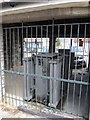
Power under the bonnet
A row of garages along Martland Close has a surprise. The lowest two units are not available for cars, they are occupied by an electricity substation and held under roofs.
Image: © Neil Owen
Taken: 18 Jul 2024
0.12 miles
2
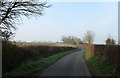
Crancombe Lane
A lane linking Woolavington and Knowle across the Polden Hills.
Image: © Derek Harper
Taken: 13 Mar 2016
0.19 miles

4
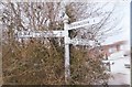
Old Direction Sign - Signpost by the B3141, Woolavington
Pyramid finial - 3 arms; Somerset SCC pyramid by the B3141, in parish of Woolavington (Sedgemoor District), Woolavington Hill junction with Cossington Lane.
Surveyed
Milestone Society National ID: SO_ST3440
Image: © Milestone Society
Taken: Unknown
0.22 miles
5
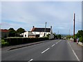
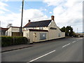
The Prince of Wales, Woolavington
The pub is situated on the west side of the B3141 in the southern half of the village. The road runs almost due north south across the whole square.
Image: © Nigel Mykura
Taken: 21 Sep 2009
0.23 miles
6
Former Prince of Wales public house, Woolavington
Closed and boarded up in 2016. Seen here, when still open, in 2009: Image
Image: © Roger Cornfoot
Taken: 13 Apr 2016
0.23 miles
7
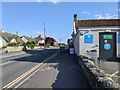
Co-op in Woolavington on the B3141, looking south
Image: © Rob Purvis
Taken: 22 Jun 2022
0.24 miles