IMAGES TAKEN NEAR TO
Meadway, BRIDGWATER, TA7 8HA
Introduction
This page details the photographs taken nearby to Meadway, TA7 8HA by members of the Geograph project.
The Geograph project started in 2005 with the aim of publishing, organising and preserving representative images for every square kilometre of Great Britain, Ireland and the Isle of Man.

There are currently over 7.5m images from over14,400 individuals and you can help contribute to the project by visiting https://www.geograph.org.uk
Image Map
Images are licensed for reuse under creativecommons.org/licenses/by-sa/2.0
Notes
- Clicking on the map will re-center to the selected point.
- The higher the marker number, the further away the image location is from the centre of the postcode.
Image Listing (22 Images Found)
Images are licensed for reuse under creativecommons.org/licenses/by-sa/2.0
Image
Details
Distance
1
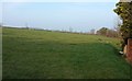
Field by Crancombe Lane
On the western edge of Woolavington, and the slopes of the Polden Hills.
Image: © Derek Harper
Taken: 13 Mar 2016
0.11 miles
2
A far reach for cement
The Cement Mixer piping piping over the roof of a house on Woolavington Hill is causing drivers some concern.
Image: © Steve Barnes
Taken: 12 Aug 2010
0.15 miles
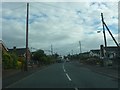
4
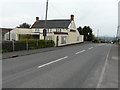
Prince Of Wales, 42 Woolavington Hill
Planning permission has been granted by Sedgemoor District Council under planning application 54/14/00016 for the “extensions and remodelling, including roof alterations and new shopfront, to facilitate permitted change from Public House (Class A4) to retail convenience store (Class A1), alterations to vehicular access and parking layout, landscaping and associated works”.
Image: © John Baker
Taken: 3 Apr 2016
0.16 miles
5
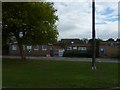
Woolavington Children's Centre & Village Primary School
Judging from the signage one of the two has some serious building work going on during the summer holidays.
Image: © Steve Barnes
Taken: 12 Aug 2010
0.18 miles
6
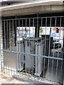
Power under the bonnet
A row of garages along Martland Close has a surprise. The lowest two units are not available for cars, they are occupied by an electricity substation and held under roofs.
Image: © Neil Owen
Taken: 18 Jul 2024
0.18 miles
7
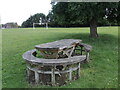
Gather round the picnic table
An unusually designed picnic table in Woolavington recreation ground. Note the goalposts in the background with some equally unusual support.
Image: © Neil Owen
Taken: 18 Jul 2024
0.20 miles
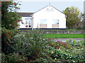
8
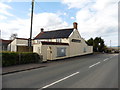
Former Prince of Wales public house, Woolavington
Closed and boarded up in 2016. Seen here, when still open, in 2009: Image
Image: © Roger Cornfoot
Taken: 13 Apr 2016
0.21 miles
9
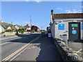
Co-op in Woolavington on the B3141, looking south
Image: © Rob Purvis
Taken: 22 Jun 2022
0.21 miles
10
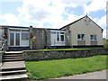
Woolavington village hall
A modern and busy community hub, complete with a defibrillator.
Image: © Neil Owen
Taken: 18 Jul 2024
0.22 miles