IMAGES TAKEN NEAR TO
Woolavington Road, BRIDGWATER, TA7 8FL
Introduction
This page details the photographs taken nearby to Woolavington Road, TA7 8FL by members of the Geograph project.
The Geograph project started in 2005 with the aim of publishing, organising and preserving representative images for every square kilometre of Great Britain, Ireland and the Isle of Man.

There are currently over 7.5m images from over14,400 individuals and you can help contribute to the project by visiting https://www.geograph.org.uk
Image Map
Images are licensed for reuse under creativecommons.org/licenses/by-sa/2.0
Notes
- Clicking on the map will re-center to the selected point.
- The higher the marker number, the further away the image location is from the centre of the postcode.
Image Listing (15 Images Found)
Images are licensed for reuse under creativecommons.org/licenses/by-sa/2.0
Image
Details
Distance
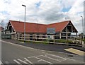
2
Woolavington surgery
Located on the Puriton road on the west end of Woolavington is the new surgery.
Image: © Neil Owen
Taken: 18 Jul 2024
0.04 miles
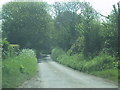
3
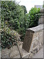
Not the most popular route
Running alongside Martlands Farm is a public footpath, marked by a suitable notch in the wall. However, it looks like not many walkers use it.
Image: © Neil Owen
Taken: 18 Jul 2024
0.06 miles
4
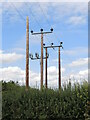
Waiting for a connection
Some poles on the Woolavington Road appear to have some weight to bear, but one does not. Also notable is the extra set of kit on the middle pole, which appears to be unconnected and to have some sort of pivoting mechanism.
Image: © Neil Owen
Taken: 18 Jul 2024
0.11 miles
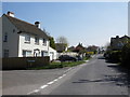
7
Higher Road, Woolavington
Which becomes the road to Puriton. Seen here close to the primary school.
Image: © Derek Harper
Taken: 13 Mar 2016
0.15 miles
8
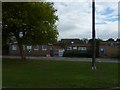
Woolavington Children's Centre & Village Primary School
Judging from the signage one of the two has some serious building work going on during the summer holidays.
Image: © Steve Barnes
Taken: 12 Aug 2010
0.16 miles
9
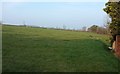
Field by Crancombe Lane
On the western edge of Woolavington, and the slopes of the Polden Hills.
Image: © Derek Harper
Taken: 13 Mar 2016
0.16 miles
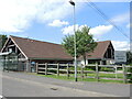
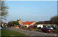
10
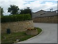
Gateway of Martland Farm
On Woolavington Road between Woolavington and Puriton.
Image: © Steve Barnes
Taken: 12 Aug 2010
0.17 miles