IMAGES TAKEN NEAR TO
Eastside Lane, BRIDGWATER, TA7 8FB
Introduction
This page details the photographs taken nearby to Eastside Lane, TA7 8FB by members of the Geograph project.
The Geograph project started in 2005 with the aim of publishing, organising and preserving representative images for every square kilometre of Great Britain, Ireland and the Isle of Man.

There are currently over 7.5m images from over14,400 individuals and you can help contribute to the project by visiting https://www.geograph.org.uk
Image Map
Images are licensed for reuse under creativecommons.org/licenses/by-sa/2.0
Notes
- Clicking on the map will re-center to the selected point.
- The higher the marker number, the further away the image location is from the centre of the postcode.
Image Listing (7 Images Found)
Images are licensed for reuse under creativecommons.org/licenses/by-sa/2.0
Image
Details
Distance
1
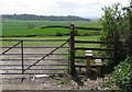
Access to footpaths along the ridge
Image: © Sarah Charlesworth
Taken: 26 Apr 2010
0.20 miles
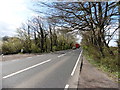
2
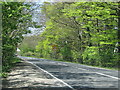
The A39 runs along the line of the Roman road
Image: © Sarah Charlesworth
Taken: 26 Apr 2010
0.20 miles
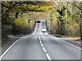

7
Moon Cottage
At the junction of Manor Road, Cossington and the A39.
Image: © Steve Barnes
Taken: 28 Aug 2009
0.25 miles