IMAGES TAKEN NEAR TO
Vicarage Road, BRIDGWATER, TA7 8DX
Introduction
This page details the photographs taken nearby to Vicarage Road, TA7 8DX by members of the Geograph project.
The Geograph project started in 2005 with the aim of publishing, organising and preserving representative images for every square kilometre of Great Britain, Ireland and the Isle of Man.

There are currently over 7.5m images from over14,400 individuals and you can help contribute to the project by visiting https://www.geograph.org.uk
Image Map
Images are licensed for reuse under creativecommons.org/licenses/by-sa/2.0
Notes
- Clicking on the map will re-center to the selected point.
- The higher the marker number, the further away the image location is from the centre of the postcode.
Image Listing (56 Images Found)
Images are licensed for reuse under creativecommons.org/licenses/by-sa/2.0
Image
Details
Distance
1
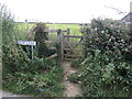
Footpath on Elm Lane
A trip across the field to Coombe Lane.
Image: © Neil Owen
Taken: 18 Jul 2024
0.06 miles
3
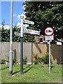
At Woolavington crossroads
Where the Higher Road, Vicarage Road and Lockwell meet is a signpost. It is a typical Somerset style version, note the arms pointing to 'ROF'. That is a reference to the Royal Ordnance Factory a few miles down the road, which made various chemical products including explosives. That factory began work in WWII and went on into privatisation in 1985; it later closed completely in 2008 and is now hoped to become the site of a 'giga-factory' producing electric batteries for transport.
Image: © Neil Owen
Taken: 18 Jul 2024
0.09 miles
4
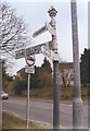
Old Direction Sign - Signpost by the B3141, Woolavington
Pyramid finial - 4 arms; Somerset SCC pyramid (ROF) by the B3141, in parish of Woolavington (Sedgemoor District), Lockswell, Higher Road junction.
Surveyed
Milestone Society National ID: SO_ST3441
Image: © Milestone Society
Taken: Unknown
0.09 miles
5
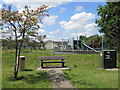
Diamond seat
A public seat by the playing fields is a monument to the Queen's Diamond Jubilee of 2012.
Image: © Neil Owen
Taken: 18 Jul 2024
0.10 miles
6
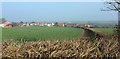
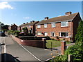
Field at Woolavington
The field on the other side of the hedge from Image The houses are at the eastern side of the village of Woolavington. On the left is Hurmans Farm.
Image: © Derek Harper
Taken: 13 Mar 2016
0.11 miles
7
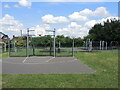
All sorts of sports
The play area hosts lots of different activities.
Image: © Neil Owen
Taken: 18 Jul 2024
0.11 miles
8
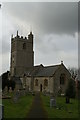
Blessed Virgin Mary Church, Woolavington
Image: © Adrian and Janet Quantock
Taken: 18 Feb 2006
0.12 miles
10
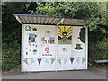
The Queen's bus stop
One of the shelters in Woolavington has been given over to tributes to the late Queen Elizabeth by the W. I. and local children.
Image: © Neil Owen
Taken: 18 Jul 2024
0.12 miles