IMAGES TAKEN NEAR TO
Moorland, BRIDGWATER, TA7 0AL
Introduction
This page details the photographs taken nearby to TA7 0AL by members of the Geograph project.
The Geograph project started in 2005 with the aim of publishing, organising and preserving representative images for every square kilometre of Great Britain, Ireland and the Isle of Man.

There are currently over 7.5m images from over14,400 individuals and you can help contribute to the project by visiting https://www.geograph.org.uk
Image Map (Loading...)


Getting Data...Please wait
Leaflet Map data © OpenStreetMap
Images are licensed for reuse under creativecommons.org/licenses/by-sa/2.0
Notes
- Clicking on the map will re-center to the selected point.
- The higher the marker number, the further away the image location is from the centre of the postcode.
Image Listing (15 Images Found)
Images are licensed for reuse under creativecommons.org/licenses/by-sa/2.0
Image
Details
Distance
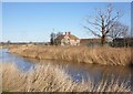
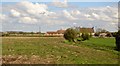
6
Linden Farm, almost hidden by riverside vegetation
Image: © David Smith
Taken: 1 Jul 2022
0.05 miles
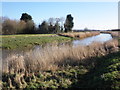
10
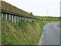
Flood defence wall by the River Parrett
Image: © Ken Grainger
Taken: 25 Jun 2009
0.15 miles