IMAGES TAKEN NEAR TO
Greenacre, BRIDGWATER, TA6 7RE
Introduction
This page details the photographs taken nearby to Greenacre, TA6 7RE by members of the Geograph project.
The Geograph project started in 2005 with the aim of publishing, organising and preserving representative images for every square kilometre of Great Britain, Ireland and the Isle of Man.

There are currently over 7.5m images from over14,400 individuals and you can help contribute to the project by visiting https://www.geograph.org.uk
Image Map (Loading...)


Getting Data...Please wait
Leaflet Map data © OpenStreetMap
Images are licensed for reuse under creativecommons.org/licenses/by-sa/2.0
Notes
- Clicking on the map will re-center to the selected point.
- The higher the marker number, the further away the image location is from the centre of the postcode.
Image Listing (20 Images Found)
Images are licensed for reuse under creativecommons.org/licenses/by-sa/2.0
Image
Details
Distance
1
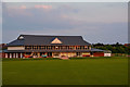
Wembdon : Wembdon Cricket Club
Looking towards the cricket club in Wembdon.
Image: © Lewis Clarke
Taken: 22 May 2018
0.10 miles
2
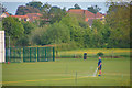
Wembdon : Wembdon Cricket Club
Looking towards a man on the pitch at the cricket club.
Image: © Lewis Clarke
Taken: 22 May 2018
0.11 miles
3
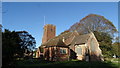
St. Georges, Wembdon
Tucked away on a quiet road on the very edge of Wembdon, the parish church was looking splendid in the spring sunshine and the bells were pealing as well!
Image: © Barbara Cook
Taken: 3 Apr 2006
0.14 miles
4
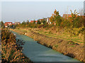
Nature reserve alongside Homberg Way
Separating Bridgwater and Wembdon Village
Image: © Ken Grainger
Taken: 12 Oct 2008
0.14 miles
5

Wembdon : Blakes Lane
Looking along Blakes Lane.
Image: © Lewis Clarke
Taken: 22 May 2018
0.15 miles
6

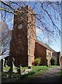
Wembdon : St George's Church
St George's Church stands in the conservative evangelical tradition of the Church of England. It has passed resolutions to reject the ordination of women.
Image: © Lewis Clarke
Taken: 22 May 2018
0.16 miles
7

Wembdon : Blakes Lane
Looking along Blakes Lane in Wembdon.
Image: © Lewis Clarke
Taken: 22 May 2018
0.17 miles
8

Ordnance Survey 1GL Bolt
This OS Bolt can be found on the west face of Wembdon Church. It marks a point 8.8849m above mean sea level.
Image: © Adrian Dust
Taken: 19 Oct 2015
0.17 miles
9

Wembdon : St George's Church
The Anglican St George's Church was founded in the 13th century in the village of Wembdon within the English county of Somerset. The current building dates from the 14th and 15th century but was largely rebuilt in 1868 after a fire. It is a Grade II listed building.
Image: © Lewis Clarke
Taken: 22 May 2018
0.17 miles