IMAGES TAKEN NEAR TO
Willoughby Road, BRIDGWATER, TA6 7NA
Introduction
This page details the photographs taken nearby to Willoughby Road, TA6 7NA by members of the Geograph project.
The Geograph project started in 2005 with the aim of publishing, organising and preserving representative images for every square kilometre of Great Britain, Ireland and the Isle of Man.

There are currently over 7.5m images from over14,400 individuals and you can help contribute to the project by visiting https://www.geograph.org.uk
Image Map (14 Images)


Leaflet Map data © OpenStreetMap
Images are licensed for reuse under creativecommons.org/licenses/by-sa/2.0
Notes
- Clicking on the map will re-center to the selected point.
- The higher the marker number, the further away the image location is from the centre of the postcode.
Image Listing (14 Images Found)
Images are licensed for reuse under creativecommons.org/licenses/by-sa/2.0
Image
Details
Distance
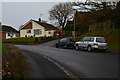
1
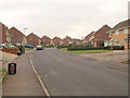
Alfoxton Road, Bridgwater
A road on Northfield, a large modern estate that climbs the hills west of Bridgwater.
Image: © Derek Harper
Taken: 26 Jan 2010
0.05 miles
2
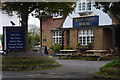
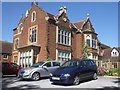
Bridgwater : West India House
The building as you see it today was constructed in 1936 but there had been a pub on the site for many years previously in various guises.
Image: © Lewis Clarke
Taken: 20 Feb 2016
0.15 miles
3
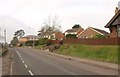
Durleigh Road
The road runs along the southern edge of the Northfield estate.
Image: © Derek Harper
Taken: 26 Jan 2010
0.16 miles
4
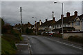
Bridgwater : Durleigh Road
Looking along Durleigh Road in Bridgwater.
Image: © Lewis Clarke
Taken: 20 Feb 2016
0.17 miles
6
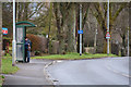
Bridgwater : Durleigh Road & Bus Stop
Looking along Durleigh Road with some people waiting for the next bus.
Image: © Lewis Clarke
Taken: 20 Feb 2016
0.18 miles
7
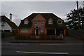
Bridgwater : 141 Durleigh Road
A house on Durleigh Road in Bridgwater.
Image: © Lewis Clarke
Taken: 20 Feb 2016
0.19 miles
8
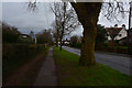
Bridgwater : Durleigh Road
A footpath heading alongside Durleigh Road.
Image: © Lewis Clarke
Taken: 20 Feb 2016
0.20 miles
9
Bridgwater : Mayfield Drive
A small residential road off of Durleigh Drive.
Image: © Lewis Clarke
Taken: 20 Feb 2016
0.20 miles
10
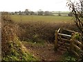
Footpath junction below Durleigh Road
The kissing gate seen in Image and Image from a third direction, from footpath BW 38/30 as it meets BW 38/17. Across the field, the line of trees marks the course of the Durleigh Brook.
Image: © Derek Harper
Taken: 26 Jan 2010
0.21 miles