IMAGES TAKEN NEAR TO
Andersfield Close, BRIDGWATER, TA6 7JW
Introduction
This page details the photographs taken nearby to Andersfield Close, TA6 7JW by members of the Geograph project.
The Geograph project started in 2005 with the aim of publishing, organising and preserving representative images for every square kilometre of Great Britain, Ireland and the Isle of Man.

There are currently over 7.5m images from over14,400 individuals and you can help contribute to the project by visiting https://www.geograph.org.uk
Image Map (Loading...)


Getting Data...Please wait
Leaflet Map data © OpenStreetMap
Images are licensed for reuse under creativecommons.org/licenses/by-sa/2.0
Notes
- Clicking on the map will re-center to the selected point.
- The higher the marker number, the further away the image location is from the centre of the postcode.
Image Listing (7 Images Found)
Images are licensed for reuse under creativecommons.org/licenses/by-sa/2.0
Image
Details
Distance
1
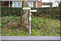
Old Direction Sign - Signpost by Durleigh Road, Durleigh Parish
Pyramid finial - 3 arms; Somerset SCC pyramid by the UC road, in parish of Durleigh (Sedgemoor District), Durleigh Road junction with Durleigh Hill.
Surveyed
Milestone Society National ID: SO_ST2736B
Image: © Milestone Society
Taken: Unknown
0.14 miles
2
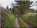
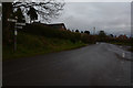
Bridgwater : Spaxton Road
A road heading from here and out away from Bridgwater.
Image: © Lewis Clarke
Taken: 20 Feb 2016
0.15 miles
3
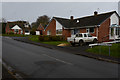
Bridgwater : Luxborough Road
A residential road off of Spaxton Road.
Image: © Lewis Clarke
Taken: 20 Feb 2016
0.15 miles
4
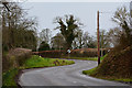
Bridgwater : Spaxton Road
A road heading into the town of Bridgwater.
Image: © Lewis Clarke
Taken: 20 Feb 2016
0.16 miles
5
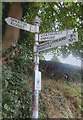
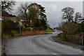
Bridgwater : Signpost
A signpost seen on Spaxton Road.
Image: © Lewis Clarke
Taken: 20 Feb 2016
0.17 miles
6
Bridgwater : Durleigh Road
Looking along Durleigh Road as it heads through Bridgwater.
Image: © Lewis Clarke
Taken: 20 Feb 2016
0.19 miles