IMAGES TAKEN NEAR TO
Buckingham Close, BRIDGWATER, TA6 6UD
Introduction
This page details the photographs taken nearby to Buckingham Close, TA6 6UD by members of the Geograph project.
The Geograph project started in 2005 with the aim of publishing, organising and preserving representative images for every square kilometre of Great Britain, Ireland and the Isle of Man.

There are currently over 7.5m images from over14,400 individuals and you can help contribute to the project by visiting https://www.geograph.org.uk
Image Map (Loading...)


Getting Data...Please wait
Leaflet Map data © OpenStreetMap
Images are licensed for reuse under creativecommons.org/licenses/by-sa/2.0
Notes
- Clicking on the map will re-center to the selected point.
- The higher the marker number, the further away the image location is from the centre of the postcode.
Image Listing (38 Images Found)
Images are licensed for reuse under creativecommons.org/licenses/by-sa/2.0
Image
Details
Distance
1
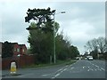
Taunton Road, Bridgwater (A38)
The junction with Wills Road
Image: © David Smith
Taken: 14 Apr 2011
0.03 miles
2
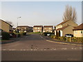
Regent Way, Bridgwater
A turning off Image into the Hamp estate; ahead is Ringwood Road.
Image: © Derek Harper
Taken: 26 Jan 2010
0.03 miles
3
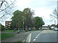
Bus stop on Taunton Road
On the left, Ringwood extends to just behind the bus stop, allowing pedestrian and cyclist access.
Image: © David Smith
Taken: 14 Apr 2011
0.05 miles
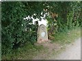
4
Hamp Bridge, A38, Bridgwater
On the Taunton Road (A38). The drainage ditch is largely is largely superseded with modern topology at this location.
Inscription: Somerset County Council Hamp Bridge re-built 1926
Milestone Society National ID: SO_ BRIDG05br
Image: © Mr Red
Taken: 29 May 2024
0.07 miles
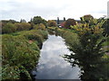
5
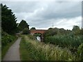
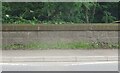
Canal and towpath, Merretts Farm, Bridgwater
Image: © David Smith
Taken: 5 Aug 2020
0.07 miles
6
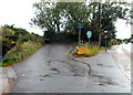
Junction near Hamp Bridge, Bridgwater
The No Through Road sign is alongside the lane diverging from the A38 Taunton Road.
A few metres out of shot ahead, the lane crosses Hamp Bridge over the Bridgwater and Taunton Canal.
Image: © Jaggery
Taken: 4 Oct 2012
0.08 miles
7
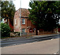
Grade II listed Hamp Cottage, Bridgwater
Viewed across the A38 Taunton Road. Partly hidden by trees, Hamp Cottage dates from the mid 18th century. The blind window is a reminder of the measures taken by some householders to reduce their liability under the Window Tax, introduced in 1696 in the reign of King William III, repealed in 1851.
Image: © Jaggery
Taken: 4 Oct 2012
0.08 miles
8
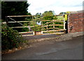
Hamp Bridge canal access for walkers, Bridgwater
On the north side of this http://www.geograph.org.uk/photo/4320579 road bridge over the Bridgwater and Taunton Canal,
a gap in the metal barrier gives walkers access to the canal path.
Image: © Jaggery
Taken: 4 Oct 2012
0.08 miles
10
Canal SE of Hamp Bridge, Bridgwater
The Bridgwater and Taunton Canal viewed from here. http://www.geograph.org.uk/photo/4320579
Image: © Jaggery
Taken: 4 Oct 2012
0.09 miles