IMAGES TAKEN NEAR TO
Fore Street, BRIDGWATER, TA6 6RY
Introduction
This page details the photographs taken nearby to Fore Street, TA6 6RY by members of the Geograph project.
The Geograph project started in 2005 with the aim of publishing, organising and preserving representative images for every square kilometre of Great Britain, Ireland and the Isle of Man.

There are currently over 7.5m images from over14,400 individuals and you can help contribute to the project by visiting https://www.geograph.org.uk
Image Map (Loading...)


Getting Data...Please wait
Leaflet Map data © OpenStreetMap
Images are licensed for reuse under creativecommons.org/licenses/by-sa/2.0
Notes
- Clicking on the map will re-center to the selected point.
- The higher the marker number, the further away the image location is from the centre of the postcode.
Image Listing (142 Images Found)
Images are licensed for reuse under creativecommons.org/licenses/by-sa/2.0
Image
Details
Distance
2

North Petherton brook
Unnamed watercourse which flows from under the A38 through the centre of the town.
Image: © Jonathan Billinger
Taken: 18 Dec 2009
0.02 miles
3
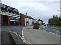
Bend with junction, Fore Street, North Petherton
The A38 towards Bridgwater.
Image: © JThomas
Taken: 10 May 2013
0.02 miles
4
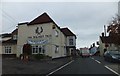
The Walnut Tree Inn with the Swan Inn opposite
Image: © David Smith
Taken: 5 Nov 2011
0.03 miles
5
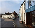
Fore Street, North Petherton
The buildings on the left also appear in Image, and see Image The shops on the right are seen in reverse in Image
Image: © Derek Harper
Taken: 16 Jan 2010
0.03 miles
7
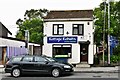
North Petherton: Lloyds Pharmacy and Craftsmen Furnishers
Image: © Michael Garlick
Taken: 26 Jun 2019
0.03 miles
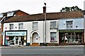
8

Shops in North Petherton
On the A38, Fore Street. The pillar box, which is close to the easting gridline, is number TA6 157.
Image: © Derek Harper
Taken: 16 Jan 2010
0.04 miles
9
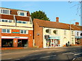
North Petherton library
A facility of the small town between Bridgwater and Taunton.
The building dates to the 1980's.
Image: © Jonathan Billinger
Taken: 18 Dec 2009
0.04 miles
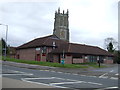
10
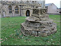
Old cross in the churchyard
St Mary's church is a fairly old one and the yard contains a stone cross base. It used to have a long, straight shaft but it was declared unsafe and demolished in 1962. Grade II* listed, nevertheless.
Image: © Neil Owen
Taken: 23 Feb 2023
0.04 miles